Maer, Cornwall
Coordinates: 50°50′21″N 4°33′03″W / 50.83912°N 4.55075°W
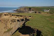
Maer Cliff, Cornwall
Maer is a coastal hamlet in north Cornwall, England, United Kingdom. It is situated one mile (1.6 km) northeast of Bude at grid reference SS 205 075[1] in the civil parish of Bude-Stratton.
The National Trust maintains Maer Down and Maer Cliff immediately west of the hamlet. The South West Coast Path runs along the clifftop past Maer.[1]
References
Cornwall Portal | |
| Unitary authorities | |
| Major settlements |
|
| Rivers | |
| Topics | |
This article is issued from Wikipedia - version of the 10/11/2016. The text is available under the Creative Commons Attribution/Share Alike but additional terms may apply for the media files.