Mandelbachtal
| Mandelbachtal | ||
|---|---|---|
| ||
 Mandelbachtal | ||
Location of Mandelbachtal within Saarpfalz district 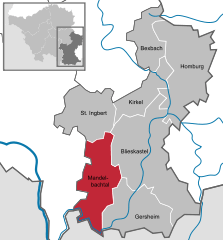
 | ||
| Coordinates: 49°10′N 7°10′E / 49.167°N 7.167°ECoordinates: 49°10′N 7°10′E / 49.167°N 7.167°E | ||
| Country | Germany | |
| State | Saarland | |
| District | Saarpfalz | |
| Government | ||
| • Mayor | Gerd Tussing (CDU) | |
| Area | ||
| • Total | 57.71 km2 (22.28 sq mi) | |
| Population (2015-12-31)[1] | ||
| • Total | 10,847 | |
| • Density | 190/km2 (490/sq mi) | |
| Time zone | CET/CEST (UTC+1/+2) | |
| Postal codes | 66399 | |
| Dialling codes | 06803 06804 06893 | |
| Vehicle registration | HOM | |
| Website | www.mandelbachtal.de | |

Mandelbachtal is a municipality in the Saarpfalz district, in Saarland, Germany. It is situated near the border with France, approx. 15 km southeast of Saarbrücken. Its capital is Ommersheim.
| Wikimedia Commons has media related to Mandelbachtal. |
Towns and municipalities in Saarpfalz | ||
|---|---|---|
References
- ↑ "Fläche und Bevölkerung - Stand: 31.12.2015 (Basis Zensus 2011)" (PDF). Statistisches Amt des Saarlandes (in German). July 2016.
This article is issued from Wikipedia - version of the 6/22/2015. The text is available under the Creative Commons Attribution/Share Alike but additional terms may apply for the media files.