Margalla Hills National Park
| Margalla Hills National Park, Islamabad - Pakistan. | ||||||
|---|---|---|---|---|---|---|
|
IUCN category V (protected landscape/seascape) | ||||||
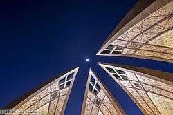
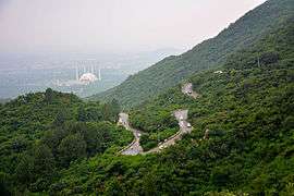
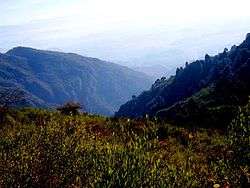
Clockwise from left: Pakistan Monument, Blue Area is the commercial center of the city, National Assembly of Pakistan, Faisal Mosque, Margalla Hills National Park Margalla hills | ||||||
 Map of Pakistan | ||||||
| Location | Northern Pakistan | |||||
| Nearest city | Islamabad | |||||
| Coordinates | 33°43′52″N 72°56′13″E / 33.731°N 72.937°ECoordinates: 33°43′52″N 72°56′13″E / 33.731°N 72.937°E[1] | |||||
| Area | 17,386 ha (67.13 sq mi) | |||||
| Established | 1980 | |||||
Margalla Hills National Park (MHNP) is a national park located on the north of the Islamabad City, within the Islamabad Capital Territory in Pakistan. The park includes the Margalla Hills which form's the foothills of the Himalayas, along with Shakarparian Park and Rawal Lake.[2]
Established in 1980, MHNP cover's approximately 17,386 hectares (67.13 sq mi), Tilla Charouni with a height of 1,604m is tallest peak in the park. MHNP is a popular tourist destination, with Daman-e-Koh and Pir Sohawa serve as popular hill stations, while Shakarparian Cultutal Complex and Lake View Park are popular picnic spots.[3]
The park is rich in biodiversity especially rich in Sino-himalayan fauna, most notably gray goral, barking deer and the Leopard.[4] Combined MHNP is home to around 600 plant species, 250 bird varieties, 38 mammals and 13 species of reptiles.[5] PTDC is currently constructing a chairlift project in the park.[6]
Location
Instituted in 1980, the Margalla Hills National Park comprises the Margalla Hills (12605 hectares) the Rawal Lake, and Shakarparian Sports and Cultural complex. Located in Islamabad, the capital of Pakistan. The hill range nestles between an elevation of 685 meters at the western end and 1,604 meters on its east.[7]
Paleontology
Millions of years ago, these mountain peaks didn’t exist. The Asian continent was mostly intact, but Indian subcontent was an island floating off the coast of Australia. Around 220 million years ago, around the time that Pangea was breaking apart, subconetent started to move northwards. It travelled some 6,000 kilometres before it finally collided with Asia around 40 to 50 million years ago. Then, part of the Indian landmass began to go beneath the Asian one, moving the Asian landmass up, which resulted in the rise of the Himalayas. It is thought that India’s coastline was denser and more firmly attached to the seabed, which is why Asia’s softer soil was pushed up rather than the other way around.How the Himalayas Were Formed The rock formations are 40 million years old, and fossils of marine life abound, it is a clear indication that before the content collision around 40 to 50 Million years ago, these hills were the seabed of the ancient ocean. Fossils of seashells, plants, petrified wood and early sea life Yorgia waggoneri are abound.
These hills are the starting point of the Himalayas. The Himalayas, which stretch some 2,900 kilometres between Pakistan, China, and Nepal, is the world’s tallest mountain range.
Flora and fauna
The vegetation of the southern slopes is short stuttered, comprising deciduous and evergreen trees with diverse shrub growth. In the north, stand pines and groves of oak. The fauna is mainly Indo Himalayan, with some overlapping of Palearctic species. The birds found here are residents as well as winter migrants from higher altitudes of the north, spring and summer visitor for breeding, and short day transit species arrive in spring.
Margalla hills have beautiful torrents gushing down in the monsoon. Natural springs are also present. Margalla has a variety of mammals, they include the Indian leopard, gray goral, barking deer, wild boar, golden jackal, red fox and the porcupine among others.
It is also home to a large number of birds such as larks, paradise flycatcher, black partridge, shrikes pheasants, spotted doves, Egyptian vultures, falcons, hawks and eagles.
Reptiles such as the Russell's viper, Indian cobra and saw-scaled viper are found here.[8]
Conservation campaigns
Himalayan Wildlife Foundation is running a project on a sustainable management strategy for the Margalla Hills National Park.
Margalla Hills Society established in 1989 is a registered non-governmental organization with its Head Office in Islamabad, Pakistan. It is managed by an elected executive council. Its main objective is to preserve the natural environment of Margalla Hills National Park and prevent shrinkage of the green areas; to promote public interest in conservation, development and management of forests, wildlife and other natural resources of Margalla hills National Park and to disseminate information about the Marghalla hills National park including its history, geography, flora, fauna culture and its benefits to the citizens of Islamabad.
Tourism, trekking and sports
The National Park is the most accessible in Pakistan due to its close proximity to the national capital, Islamabad. It is a significant hub for bird lovers throughout the year. There are several hiking trails, with the most famous being Trail 3 and trail 5.
Rock climbing
There are many spots for rock climbing in Margalla Hills. Few crags have been developed but, still a lot of potential available to explore virgin lines.[9][10]
For beginner level climbers, following crags are suggested:
| Name of crag | Number of Pitches | Difficulty Level | Average Height |
|---|---|---|---|
| Jasmine Corner (Margalla Hills) | 3 | Beginner Level | 15 meters |
| Musical Lounge | 2 | Beginner to Intermediate Level | 18 meters |
| Saidpur Village | 2 | Beginner Level | 15 meters |
| Shahdra Wall | 4 | Beginner to Intermediate Level | 13 meters |
Although, sport climbing is becoming increasingly popular among the youth of Rawalpindi and Islamabad.[11] but, only few local climbers can climb at advance level. Therefore, most of the crags remain uncrowded.
References
- ↑ "Margalla Hills National Park". protectedplanet.net.
- ↑ Administrator. "Margalla Hills National Park". www.taxilatour.com. Retrieved 2016-06-09.
- ↑ Umar, Suhail Yusuf | Muhammad (2015-01-22). "Distress calls: Wildlife at Margalla Hills under threat". www.dawn.com. Retrieved 2016-06-09.
- ↑ "Wildlife of Pakistan: Margalla Hills National Park". www.wildlifeofpakistan.com. Retrieved 2016-06-09.
- ↑ "Margalla Hills National Park: CDA to launch cleanliness drive - The Express Tribune". The Express Tribune. 2016-03-01. Retrieved 2016-06-09.
- ↑ "Margalla Hills National Park: PTDC to execute chairlift project - The Express Tribune". The Express Tribune. 2015-04-23. Retrieved 2016-06-09.
- ↑ "Preservation of Margalla Hills National Park promised". www.thenews.com.pk. Retrieved 2016-06-09.
- ↑ Birds of Islamabad
- ↑ http://www.pakistanalpine.com/rock-climbing-islamabad/
- ↑ http://www.pakistanalpine.com/rock-climbing-pakistan/
- ↑ http://www.thenews.com.pk/daily_detail.asp?id=221652


