Massachusetts Route 33
| ||||
|---|---|---|---|---|
 | ||||
| Route information | ||||
| Maintained by MassDOT | ||||
| Length: | 5.54 mi[1] (8.92 km) | |||
| Existed: | c. 1946 – present | |||
| Major junctions | ||||
| South end: |
| |||
|
| ||||
| North end: |
| |||
| Location | ||||
| Counties: | Hampden, Hampshire | |||
| Highway system | ||||
| ||||

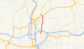
Route 33 is a state highway contained entirely within the city of Chicopee and the town of South Hadley in Massachusetts.
Route description
Route 33 begins at Route 141 just north of the Chicopee River in the Chicopee Falls section of the city. It crosses under the Massachusetts Turnpike, with the entrance ramps for Exit 5 just north of this. It passes west of Westover Joint Air Reserve Base before entering the town of South Hadley. Once in South Hadley, the road crosses U.S. Route 202, which leads westward towards Holyoke, as it turns northeast, ending at Route 116, the street itself continuing as Lyman Street.
Junction list
| County | Location | mi | km | Destinations | Notes |
|---|---|---|---|---|---|
| Hampden | Chicopee | 0.00 | 0.00 | Southern terminus of Route 33. | |
| 0.9 | 1.4 | Mass Pike Exit 5. | |||
| Hampshire | South Hadley | 4.6 | 7.4 | ||
| 5.54 | 8.92 | Northern terminus of Route 33. | |||
1.000 mi = 1.609 km; 1.000 km = 0.621 mi
| |||||
References
This article is issued from Wikipedia - version of the 5/2/2015. The text is available under the Creative Commons Attribution/Share Alike but additional terms may apply for the media files.
