Mescalitan Island
Mescalitan Island was a mesalike island located about 10 miles west of Santa Barbara near the outlet of the Goleta Slough into the Pacific Ocean.
History
Chumash
The island is where the Chumash Indian village Helo was centered. Early Spanish mission documents note that Juan Crespi, an early visitor, observed the island village to have at least 100 houses with about 600 to 800 total residents.[1]
Cabrillo
The first European explorer in the Goleta area, Portuguese navigator Juan Rodriguez Cabrillo, arrived on October 15, 1542. At this time the Goleta Slough was deep and wide enough to permit entry of large ships. A Spanish schooner, or 'goleta', reportedly sank in the lagoon area sometime thereafter. From that point on, the area became known as Goleta.[2] During a sailing trip to Northern California Cabrillo was injured, later dying of his injuries; according to some accounts he was buried on San Miguel Island. However, according to the local canaliños (Chumash) he was buried on Mescalitan Island.[3]
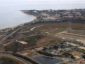
Mescalitan Island was a prominent landmark in the Goleta Slough area. In the 1860s, after years of flooding and winter storms the slough became filled in with sediment.
Leveled
In 1941 the Army Corps of Engineers leveled most of Mescalitan Island to provide fill for a Navy airport.[4] That airport became part of Marine Corps Air Station Santa Barbara in 1942, and a few years later became the Santa Barbara Municipal Airport.
Present day
The island is currently the location of the Goleta Sanitary Sewage Treatment Plant.
There is a mural depicting Mescalitan Island on the side of the Santa Cruz Market on Hollister Avenue in old town Goleta.[5]

Location
The site of Mescalitan Island is in southern Santa Barbara County, California at 34° 25' 16" N. latitude and 119° 50' W. longitude. Mescalitan Island is shown in the center of the Goleta USGS topographic quadrangle.[6]
See also
- Chumash populated places
References
- ↑ Comstock Homes Development and Ellwood Mesa Open Space Plan FEIR (PDF). 2004. pp. 4.11–4.
- ↑ "Goleta's Forgotten Treasure: A Brief History of the Goleta Slough" (PDF). Channels: Newsletter of Santa Barbara Channelkeeper. 2003. Archived from the original (PDF) on 2012. Retrieved April 6, 2015.
- ↑ "About". Goleta Valley Junior High School. Retrieved April 6, 2015.
- ↑ Isla Vista Master Plan Draft EIR: Cultural/Historic Resources. pp. 3.6–4.
- ↑ Werner, Allyson (March 3, 2014). "Old Town Mural Recalls Life in Long-Ago Goleta". Noozhawk. Retrieved April 6, 2015.
- ↑ "GOLETA Topo Map at Lat 34.4217°N Long -119.8325°W Zoom 15 S Size". Trails.com. Retrieved April 6, 2015.
External links
- Historical Accounts and Maps of the Goleta Slough
- Mescaltitlan Island at Goleta History
Coordinates: 34°25′18″N 119°50′00″W / 34.42166°N 119.83347°W