Mississippi Highway 792
| ||||
|---|---|---|---|---|
 | ||||
| Route information | ||||
| Maintained by MDOT | ||||
| Length: | 13.216 mi[1] (21.269 km) | |||
| Existed: | 1998 – present | |||
| Major junctions | ||||
| West end: |
| |||
| East end: |
| |||
| Location | ||||
| Counties: | Lowndes, Noxubee | |||
| Highway system | ||||
| ||||

Mississippi Highway 792 (MS 792) is a road in eastern Mississippi. It starts at U.S. Route 45 (US 45), and travels east. Near halfway of the route, SR 792 turns south and continues to its eastern terminus at MS 388. The highway was designated in 1998, and no major changes have been made since.
Route description
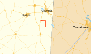
MS 792 is located in southern Lowndes and northern Noxubee counties.[2] In 2012, Mississippi Department of Transportation (MDOT) calculated as many as 1,800 vehicles traveling west of Trinity Road and Weyerhaeuser Road, and as few as 540 vehicles traveling south of Bluitt Road.[3] It is not included as a part of the National Highway System (NHS), a network of highways identified as being most important for the economy, mobility and defense of the nation.[4] The route is legally defined in Mississippi Code § 65-3-3,[5] and is maintained by the Mississippi Department of Transportation.[1]
MS 792 starts at a T-intersection with US 45, near the Black Prairie wildlife management area.[2] It travels east along Carson Road, going through a small group of trees and farmland. At Gun Club Road, the landscape changes completely into farmland.[6] Near 3.5 miles (5.6 km) later, Carson Road intersects Weyerhaeuser Road, that leads to cellulose fiber mills.[6][7][8] MS 792 later turns southeastward at Old Macon Road, and crosses over a river. South of Plum Grove Road, the route shifts slightly to the west. Old Macon Road enters Noxubee County, while crossing over a small creek. MS 792 continues south for a few more miles, before ending at MS 388.[6]
History
The route was constructed by 1998, connecting from US 45 to MS 388. At the point where MS 792 turns south in Lowndes county, it is following the original alignment of U.S. highway 45. This was the alignment for u.s. 45 from 1926 until 1938, when the current 45 was completed. MS 792 was fully paved,[9][10] and no significant changes have happened on the route since.[10][2]
Major intersections
| County | Location | mi[1] | km | Destinations[6] | Notes |
|---|---|---|---|---|---|
| Lowndes | | 0.000 | 0.000 | ||
| Noxubee | | 13.216 | 21.269 | ||
| 1.000 mi = 1.609 km; 1.000 km = 0.621 mi | |||||
References
- 1 2 3 Mississippi Department of Transportation Planning Division (December 31, 2011). Mississippi Public Roads Selected Statistics Extent, Travel, and Designation (PDF) (Report). Mississippi Department of Transportation. Retrieved July 8, 2014.
- 1 2 3 Official Highway Map of Mississippi (PDF) (Map). Cartography by Mississippi Department of Transportation. Mississippi Department of Transportation. 2012. Retrieved July 8, 2014.
- ↑ "MDOT Traffic Count Application". Mississippi Department of Transportation. Retrieved July 8, 2014.
- ↑ National Highway System: Mississippi (PDF) (Map). Federal Highway Administration. November 2003. Retrieved July 8, 2014.
- ↑ "Mississippi Code Of 1972 As Amended - SEC. 65-3-3. State highways designated.". Mississippi Legislature. Retrieved July 8, 2014.
- 1 2 3 4 Microsoft; Nokia (July 8, 2014). "Mississippi Highway 792" (Map). Bing Maps. Microsoft. Retrieved July 8, 2014.
- ↑ Google (July 9, 2014). "U.S. Route 45 at Mississippi Highway 792" (Map). Google Maps. Google. Retrieved July 9, 2014.
- ↑ "Weyerhaeuser's Columbus Cellulose Fibers mill". Weyerhaeuser. Retrieved December 1, 2014.
- ↑ Official Highway Map of Mississippi (PDF) (Map). Cartography by Mississippi Department of Transportation. Mississippi Department of Transportation. 1996–97. Retrieved July 8, 2014.
- 1 2 Official Highway Map of Mississippi (PDF) (Map). Cartography by Mississippi Department of Transportation. Mississippi Department of Transportation. 1998. Retrieved July 8, 2014.