Moel Eilio
| Moel Eilio | |
|---|---|
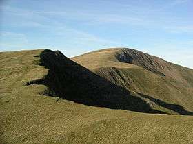 Moel Eilio from the south | |
| Highest point | |
| Elevation | 726 m (2,382 ft) |
| Prominence | 259 m (850 ft) |
| Parent peak | Snowdon |
| Listing | Marilyn, Hewitt, Nuttall |
| Naming | |
| Translation | Eilio's hill (Welsh) |
| Pronunciation | Welsh: [mɔil eiliɔ] |
| Geography | |
| Location | Gwynedd, Wales |
| Parent range | Snowdonia |
| OS grid | SH555577 |
| Topo map | OS Landranger 115 |
| Listed summits of Moel Eilio | ||||
| Name | Grid ref | Height | Status | |
|---|---|---|---|---|
| Foel Gron | 629 m (2,064 ft) | Hewitt, Nuttall | ||
| Foel Goch (Eilio) | 605 m (1,985 ft) | sub Hewitt | ||
Moel Eilio is a mountain in Snowdonia, North Wales, that is situated approximately 3 miles north-west of Snowdon itself. It has two subsidiary tops, Foel Gron and Foel Goch (Eilio). The average annual temperature of the mountain is around 6 degrees Celsius. During the winter season, some significant accumulations of snowfall is known to take place on Moel Eilio, due to its relatively flat, grassy slopes.
A popular ascent starts from Llanberis and climbs by way of Bwlch y Groes and then the north ridge of the hill.
Moel Eilio, Foel Gron, Foel Goch and Moel Cynghorion form a curved ridge tracking generally south-west towards Snowdon and can provide a less common route to ascend Snowdon.[1][2][3]
References
- ↑ Marsh, Terry (1984). The Summits of Snowdonia (London: Robert Hale, 1984). ISBN 0-7090-1456-2.
- ↑ Marsh, Terry. The Mountains of Wales (London: Hodder and Stoughton, 1985). ISBN 0-340-34827-5.
- ↑ Nuttall, John & Anne (1999). The Mountains of England & Wales - Volume 1: Wales (2nd edition ed.). Milnthorpe, Cumbria: Cicerone. ISBN 1-85284-304-7.
External links
- www.geograph.co.uk : photos of Moel Eilio and surrounding area
- Walking Routes to the Summit of Moel Eilio
Coordinates: 53°05′49″N 4°09′34″W / 53.09688°N 4.15953°W