Moju Chowdhury Hat
| Moju Chowdhury Hat মজু চৌধুরীর হাট | |
|---|---|
| Town | |
|
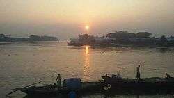
Moju Chowdhury Hat at Sunrise. | |
| Nickname(s): MCH | |
 Moju Chowdhury Hat Location in Bangladesh | |
| Coordinates: BD 22°52′29″N 90°47′05″E / 22.8745967°N 90.7846910°ECoordinates: BD 22°52′29″N 90°47′05″E / 22.8745967°N 90.7846910°E | |
| Country |
|
| Division | Chittagong Division |
| District | Lakshmipur District |
| Upazila | Lakshmipur Sadar Upazila |
| Established in | 1965 |
| Funded by Moju Chowdhury | 1966 |
| Area | |
| • Total | 145.18 km2 (56.05 sq mi) |
| Elevation | 56.05 m (183.89 ft) |
| Time zone | BST (UTC+6) |
| postal code | 3700 |
| Area code(s) | 3700 |
| Website | Official Website of Moju Chowdhury Hat |
Moju Chowdhury Hat ('Rahmat Khali, commonly known as Moju Chowdhury Hat was formerly named Rahmat Khali and was renamed in 1965 Moju Chowdhury) is a town in Lakshmipur Sadar Upazila of Lakshmipur District of Bangladesh.[1] (Bengali: মজু চৌধুরীর হাট ).
Economy
tourism ,[2]
Geography
It is located in the south-eastern part of the country close to the banks of the Meghna river. This town is 12 km² and is south of Lakshmipur City. It has 145.56 households and a total area of 56.05 km².
See also
- List of cities and towns in Bangladesh
- List of villages in Bangladesh
- Wards of Bangladesh
- Rahmat Khali Canal
References
- ↑ Nazimuddin Mahmud (2012), "Lakshmipur Sadar Upazila", in Sirajul Islam and Ahmed A. Jamal, Banglapedia: National Encyclopedia of Bangladesh (Second ed.), Asiatic Society of Bangladesh
- ↑ "Unsafe water transports ply 'danger zone' defying ban". archive.thedailystar.net. Retrieved 2016-03-10.
| Wikimedia Commons has media related to Moju Chowdhury Hat. |
This article is issued from Wikipedia - version of the 11/21/2016. The text is available under the Creative Commons Attribution/Share Alike but additional terms may apply for the media files.
