Mount Geryon
| Mount Geryon | |
|---|---|
|
The east face of Mount Geryon, as seen from the top of The Acropolis | |
| Highest point | |
| Elevation | 1,516 m (4,974 ft) [1][2] |
| Prominence | 580 m (1,900 ft) [2] |
| Isolation | 6.57 km (4.08 mi) [2] |
| Listing | 12th/15th highest mountain in Tasmania[2] |
| Coordinates | 41°55′12″S 146°03′00″E / 41.92000°S 146.05000°ECoordinates: 41°55′12″S 146°03′00″E / 41.92000°S 146.05000°E [3] |
| Geography | |
  Mount Geryon Location in Tasmania | |
| Location | Central Highlands of Tasmania, Australia |
| Parent range | Du Cane |
| Geology | |
| Age of rock | Jurassic |
| Mountain type | Dolomite |
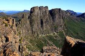
Mount Geryon is a mountain in the Central Highlands region of the Australian state of Tasmania. The mountain is part of the Du Cane Range and is situated within the Cradle Mountain-Lake St Clair National Park.
With two peaks, Mount Geryon North has an elevation of 1,516 metres (4,974 feet) above sea level and is the twelfth-highest mountain in Tasmania. Mount Geryon South, with an elevation of 1,509 metres (4,951 ft) above sea level, is the state's fifteenth-highest peak.
The mountain is a major feature of the national park, and is a popular venue with bushwalkers and mountain climbers. It has more than 40 ascent routes for climbers, some of which are over 300 metres (980 ft) in height; however, it is the impressive east face at 500 metres (1,600 ft) in height for which Mount Geryon is most popular.
There is a famous nearby tarn which is known as the Pool of Memories.
See also
References
- ↑ "LISTmap (Stacks Bluff)". Tasmanian Government Department of Primary Industries and Water. Retrieved 25 March 2008.
- 1 2 3 4 "Mount Geryon, Australia". Peakbagger.com. Retrieved 7 June 2015.
- ↑ "Mount Geryon (TAS)". Gazetteer of Australia online. Geoscience Australia, Australian Government.
External links
- Parks Tasmania
- Kiernan , Kevin (1992). "Mountain geomorphology and the Last Glaciation at Lake St Clair" (PDF). Papers and Proceedings of the Royal Society of Tasmania. Department of Geography and Environmental Studies, University of Tasmania. 126: 47–57. OCLC 271191704. Retrieved 7 June 2015.