Mount Ida (Colorado)
| Mount Ida | |
|---|---|
  Mount Ida | |
| Highest point | |
| Elevation | 12,865 ft (3,921 m) [1][2] |
| Prominence | 520 ft (158 m) [2] |
| Isolation | 1.16 mi (1.87 km) [2] |
| Coordinates | 40°22′18″N 105°46′45″W / 40.371651°N 105.7791758°WCoordinates: 40°22′18″N 105°46′45″W / 40.371651°N 105.7791758°W [3] |
| Geography | |
| Location | Grand and Larimer counties, Colorado, U.S.[3] |
| Parent range | Front Range[2] |
| Topo map |
USGS 7.5' topographic map Grand Lake, Colorado[3] |
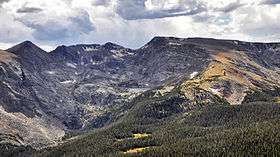
Mount Ida and Azure Lake
Mount Ida is a mountain summit in the northern Front Range of the Rocky Mountains of North America. The 12,865-foot (3,921 m) peak is located in the Rocky Mountain National Park Wilderness, 13.4 miles (21.6 km) west (bearing 268°) of the Town of Estes Park, Colorado, United States, on the Continental Divide between Grand and Larimer counties.[1][2][3][4] The mountain was probably named after Mount Ida on Crete.[5]
See also
- List of Colorado mountain ranges
- List of Colorado mountain summits
- List of Colorado county high points
References
- 1 2 The elevation of Mount Ida includes an adjustment of +1.633 m (+5.36 ft) from NGVD 29 to NAVD 88.
- 1 2 3 4 5 "Mount Ida, Colorado". Peakbagger.com. Retrieved November 30, 2014.
- 1 2 3 4 "Mount Ida". Geographic Names Information System. United States Geological Survey. Retrieved November 30, 2014.
- ↑ "Mount Ida". Peakery.com. Retrieved 22 November 2014.
- ↑ Dziezynski, James (1 August 2012). Best Summit Hikes in Colorado: An Opinionated Guide to 50+ Ascents of Classic and Little-Known Peaks from 8,144 to 14,433 Feet. Wilderness Press. p. 110. ISBN 978-0-89997-713-3.
External links

This article is issued from Wikipedia - version of the 10/31/2016. The text is available under the Creative Commons Attribution/Share Alike but additional terms may apply for the media files.