Mount Saskatchewan (Alberta)
| Mount Saskatchewan | |
|---|---|
 Mount Saskatchewan | |
| Highest point | |
| Elevation | 3,342 m (10,965 ft) [1] |
| Prominence | 1,102 m (3,615 ft) [2] |
| Coordinates | 52°06′06″N 117°05′42″W / 52.10167°N 117.09500°WCoordinates: 52°06′06″N 117°05′42″W / 52.10167°N 117.09500°W [2] |
| Geography | |
| Location | Alberta, Canada |
| Parent range | Columbia Icefield |
| Topo map | NTS 83C/03 |
| Climbing | |
| First ascent | 1923 by Conrad Kain, W.S. Ladd, J. Monroe Thorington[2] |
| Easiest route | technical climb |
- For the peak by this name in Kluane National Park, see Mount Saskatchewan (Yukon).
Mount Saskatchewan is a mountain located in the North Saskatchewan River valley of Banff National Park, in the Canadian Rockies of Alberta, Canada.
J. Norman Collie named the mountain in 1898 for the nearby Saskatchewan River.[2]
Lighthouse Tower

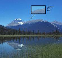
Mount Saskatchewan with magnified inset of Lighthouse Tower.
A 75-metre pinnacle unofficially named Lighthouse Tower (elevation 2,960 m (9,710 ft)) is located on the eastern ridge of the mountain.[1] It was first climbed in 1964 by G. Boehnisch and L. Mackay.
References
- 1 2 "Mount Saskatchewan". PeakFinder.com. Retrieved 2007-09-02.
- 1 2 3 4 "Mount Saskatchewan". Bivouac.com. Retrieved 2009-01-02.
This article is issued from Wikipedia - version of the 5/24/2015. The text is available under the Creative Commons Attribution/Share Alike but additional terms may apply for the media files.