New Ipswich Center Village Historic District
|
New Ipswich Center Village Historic District | |
 | |
| Location | Roughly bounded by Turnpike Rd., Porter Hill Rd., Main St., NH 123A, Preston Hill, Manley and King Rds., New Ipswich, New Hampshire |
|---|---|
| Area | 325 acres (132 ha) |
| Architectural style | Greek Revival, Georgian, Federal |
| NRHP Reference # | 91001173[1] |
| Added to NRHP | September 3, 1991 |
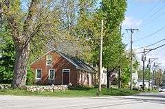
The New Ipswich Center Village Historic District encompasses the historic center of the rural town of New Ipswich, New Hampshire. The center village is the town's most densely populated area, with a history dating to the town's founding in 1735. The district extends along Turnpike Road (New Hampshire Route 124) between King and Porter Roads, and southward in a roughly triangular shape, the southern point of which is at the junction of Main Street (New Hampshire Route 123A) and Willard Road. The village includes a large number of residences, which were mainly agricultural at first, but also include a number of properties built as summer resort houses in the late 19th and early 20th centuries. It also includes most of the town's historic civic buildings, including its historic town hall, and the Barrett House, now a museum property owned by Historic New England.[2] The district was listed on the National Register of Historic Places in 1991.[1]
See also
References
- 1 2 National Park Service (2010-07-09). "National Register Information System". National Register of Historic Places. National Park Service.
- ↑ "NRHP nomination for New Ipswich Center Village Historic District" (PDF). National Park Service. Retrieved 2014-05-29.
| Topics |  | |
|---|---|---|
| Lists by county | ||
| Other lists | ||
| ||