Nine Mile Burn
Coordinates: 55°48′18″N 3°18′47″W / 55.805°N 3.313°W
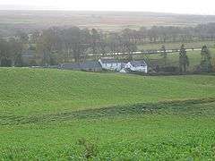
Pentland hills near Nine Mile Burn on the A702
Nine Mile Burn is the last hamlet in Midlothian, Scotland when heading south on the A702 road.
It is located next to the Pentland Hills, about 2 km north-east of the village of Carlops, and is in the parish of Penicuik.
External links
| Wikimedia Commons has media related to Nine Mile Burn. |
This article is issued from Wikipedia - version of the 6/14/2016. The text is available under the Creative Commons Attribution/Share Alike but additional terms may apply for the media files.