Numbugga, New South Wales
| Numbugga New South Wales | |
|---|---|
| Population | 307 (2006 census)[1] |
| Postcode(s) | 2550 |
| Elevation | 156 m (512 ft) |
| LGA(s) | Bega Valley Shire |
| State electorate(s) | Bega[2] |
| Federal Division(s) | Eden-Monaro[3] |
Numbugga (36°39′S 149°42′E / 36.650°S 149.700°E), New South Wales, Australia, is a locality about 15 km from the town of Bega, in Bega Valley Shire, consisting of mainly farmland, rural residential dwellings and National Parks. At the 2006 census, Numbugga had a population of 307 people.[1]
History
Numbugga was settled around the same times as the nearby towns of Bega and Bemboka. The present route of the Snowy Mountains Highway follows the old route, except for a few deviations that are now roads in their own right, such as Coopers Gully Road and Garfield Road. The area used to have three schools until the mid-1970s. A hall used to stand close to the location of the current Numbugga Bushfire Brigade shed. The Numbugga Bushfire Brigade is part of the NSW RFS
Photo Gallery
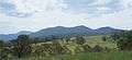 Part of the Numbugga Walls mountain range
Notes and references
- 1 2 Australian Bureau of Statistics (25 October 2007). "Numbugga (State Suburb)". 2006 Census QuickStats. Retrieved 7 November 2009.
- ↑ "Bega District Profile". NSW Electoral Commission. Retrieved 19 February 2011.
- ↑ "Division of Eden-Monaro (NSW)". Australian Electoral Commission. Retrieved 19 February 2011.