Obroshyne
| Obroshyne Обро́шине | |
|---|---|
| village | |
 Obroshyne | |
| Coordinates: UA 49°47′07″N 23°52′07″E / 49.78528°N 23.86861°ECoordinates: UA 49°47′07″N 23°52′07″E / 49.78528°N 23.86861°E | |
| Country |
|
| Province |
|
| District |
|
| Established | 1447 |
| Area | |
| • Total | 20 km2 (8 sq mi) |
| Elevation/(average value of) | 314 m (1,030 ft) |
| Population | |
| • Total | 4,186 |
| • Density | 209,3/km2 (5,420/sq mi) |
| Time zone | EET (UTC+2) |
| • Summer (DST) | EEST (UTC+3) |
| Postal code | 81115 |
| Area code | +380 3230 |
| Website | село Оброшине (Ukrainian) |
Obroshyne (Ukrainian: Обро́шине) is a village in Pustomyty Raion, Lviv Oblast in western Ukraine.
The population of the village is about 4186. Local government is administered by the village council.[1]
Geography
Obroshyne is located along Highway M06 (Ukraine) (![]() ), which goes from Kiev to the Hungarian border near Chop. It is 16 kilometres (9.9 mi) from the regional center, Lviv, 8 kilometres (5.0 mi) from the district center, Pustomyty, and 274 kilometres (170 mi) from Chop.[2] The village of Basivka is 4 kilometres (2.5 mi) away.
), which goes from Kiev to the Hungarian border near Chop. It is 16 kilometres (9.9 mi) from the regional center, Lviv, 8 kilometres (5.0 mi) from the district center, Pustomyty, and 274 kilometres (170 mi) from Chop.[2] The village of Basivka is 4 kilometres (2.5 mi) away.
History
The first written mention of the village of Obroshyne dates to 1447.[3] In 1456 King Casimir IV Jagiellon of Poland gave the estate to the Roman Catholic Archdiocese of Lviv.
Religious buildings
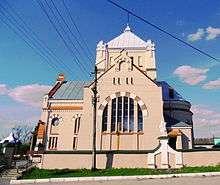
- Church of St. Demetrius, 1914
- Roman Catholic Church, 1791 (in disrepair)[4]
Attractions
The village contains the following national heritage sites:
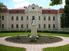
- Lviv Archbishops Residence, 1730 (number 477/0)
- Palace, 1730 ( number 477/1 )
- Bell tower of St. Demetrius, 1774 (number 491-M)
In addition, Obroshyn dendropark is of national importance.
Notable residents
- Lev Shankovsky (1903 - 1995). He and his wife were schoolteachers in the locality.
References
External links
| Wikimedia Commons has media related to Obroshyne. |
- Village of Obroshyne
- Оброшинська ЗОШ ім.Л.Шанковського І-ІІІ ст., Лев Шанковський (Ukrainian)
- Вісник Нац. ун-ту «Львівська політехніка» : Професор Лев Полюга (квітка на могилу) / Олександра Сербенська, Серія «Проблеми української термінології» – 2012. – № 733. – С. 255–257. (Ukrainian)
Sources
- Ukrainian: (Історія міст і сіл УРСР : Львівська область. – К. : ГРУРЕ, 1968 р.) Page 603