Ohio State Route 243
| ||||
|---|---|---|---|---|
 | ||||
| Route information | ||||
| Maintained by ODOT | ||||
| Length: | 18.39 mi[1] (29.60 km) | |||
| Existed: | 1925[2][3] – present | |||
| Major junctions | ||||
| West end: |
 US 52 in Coal Grove US 52 in Coal Grove | |||
| East end: |
 SR 7 near Proctorville SR 7 near Proctorville | |||
| Location | ||||
| Counties: | Lawrence | |||
| Highway system | ||||
| ||||


.svg.png)
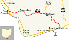
State Route 243 (SR 243) is an east–west state highway in the southern portion of the U.S. state of Ohio. The western terminus of SR 243 is at a diamond interchange with the U.S. Route 52 (US 52) in Coal Grove. The eastern terminus of the state highway is at its signalized junction with State Route 7 approximately 1.25 miles (2.01 km) west of Proctorville near the northern banks of the Ohio River.
SR 243 used to continue east from here, running concurrently with SR 7 into Proctorville, then split briefly from SR 7 as it passed through the community of Rome before ending at SR 7 about 3 miles (4.8 km) east of Proctorville.
History
SR 243 between SR 7, in Proctorville, and SR 7 northeast of Proctorville, was signed in 1923 as SR 219.[4][5] In 1925, SR 219 was replaced by SR 243.[2][3] This section of road was paved in 1929.[6][7] The western terminus was moved west to Coalgrove, concurrent with SR 7 through Proctorville, in 1932.[8][9] The paving of the route between Coalgrove and Proctorville was completed by 1955.[10][11] On December 11, 2006, SR 243 was truncated to its present location following completion of the new SR 775 by-pass of Proctorville, which SR 7 was re-routed onto, leaving jurisdiction of the former routings of SSR 7 and SR 243 through Proctorville to be turned over from the state to the local jurisdictions.[12]
Major intersections
The entire route is in Lawrence County.
| Location | mi[1] | km | Destinations | Notes | |
|---|---|---|---|---|---|
| Coal Grove | 0.00 | 0.00 |   US 52 / US 52 Bus. west – Chesapeake, Portsmouth, Ironton US 52 / US 52 Bus. west – Chesapeake, Portsmouth, Ironton | Interchange; eastern terminus of US 52 Bus. | |
| Union Township | 11.59 | 18.65 |  SR 378 north SR 378 north | Southern terminus of SR 378 | |
| 18.39 | 29.60 | SR 7 | |||
| 1.000 mi = 1.609 km; 1.000 km = 0.621 mi | |||||
References
- 1 2 Ohio Department of Transportation. "Technical Services Straight Line Diagrams" (PDF). Retrieved December 16, 2013.
- 1 2 Ohio Department of Highways and Public Works (August 1924). Map of Ohio Showing State Routes (MrSID) (Map). 1:760,320. Columbus: Ohio Department of Highways and Public Works. Retrieved September 13, 2013.
- 1 2 Ohio Department of Highways and Public Works (August 1925). Map of Ohio Showing State Routes (MrSID) (Map). 1:760,320. Columbus: Ohio Department of Highways and Public Works. OCLC 5673562. Retrieved September 13, 2013.
- ↑ Ohio Department of Highways and Public Works (April 1922). Map of Ohio State Highways (MrSID) (Map). Columbus: Ohio Department of Highways and Public Works. Retrieved September 13, 2013.
- ↑ Ohio Department of Highways and Public Works (July 1923). Map of Ohio Showing State Routes (MrSID) (Map). 1:760,320. Columbus: Ohio Department of Highways and Public Works. Retrieved September 13, 2013.
- ↑ Ohio Department of Highways (August 1, 1928). Map of Ohio Showing State Routes (MrSID) (Map). 1:760,320. Columbus: Ohio Department of Highways. OCLC 5673562, 7434854. Retrieved September 13, 2013.
- ↑ Ohio Department of Highways (August 15, 1929). Map of Ohio Showing State Routes (MrSID) (Map). 1:760,320. Columbus: Ohio Department of Highways. OCLC 5673562, 7438560. Retrieved September 13, 2013.
- ↑ Ohio Department of Highways (1931). Map of Ohio Showing State Routes (MrSID) (Map). 1:760,320. Columbus: Ohio Department of Highways. OCLC 5673562, 7231737. Retrieved September 13, 2013.
- ↑ Ohio Department of Highways (1932). Map of Ohio Showing State Routes (MrSID) (Map). 1:760,320. Columbus: Ohio Department of Highways. OCLC 5673562, 7231704. Retrieved September 13, 2013.
- ↑ Ohio Department of Highways (1953). Official Highway Map of Ohio (MrSID) (Map). 1:633,600. Columbus: Ohio Department of Highways. OCLC 5673562, 7448735. Retrieved September 13, 2013.
- ↑ Ohio Department of Highways (1955). Official Highway Map of Ohio (MrSID) (Map). 1:633,600. Columbus: Ohio Department of Highways. OCLC 5673562, 7448742. Retrieved September 13, 2013.
- ↑ "Straight Line Diagrams 1/2007 Updates". Ohio Department of Transportation. Retrieved September 13, 2013.