Ohio State Route 260
| ||||
|---|---|---|---|---|
 | ||||
| Route information | ||||
| Maintained by ODOT | ||||
| Length: | 36.67 mi[1] (59.01 km) | |||
| Existed: | 1926 – present | |||
| Major junctions | ||||
| South end: |
 SR 7 in Matamoras SR 7 in Matamoras | |||
| North end: |
 SR 78 near East Union SR 78 near East Union | |||
| Location | ||||
| Counties: | Washington, Monroe, Noble | |||
| Highway system | ||||
| ||||


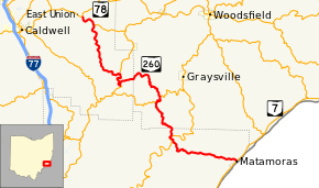
State Route 260 (SR 260) is a 36.67-mile-long (59.01 km) state highway in southeastern Ohio. The route runs from SR 7 in Matamoras to SR 78 near East Union.
Route description
The route is signed as a north-south highway though it runs northwest-southeast between Matamoras and East Union.[2] No part of the route is a part of the National Highway System.[3]
History
SR 260 was first assigned around 1926 on its present alignment between SR 145 in Road Fork to SR 78 near East Union, entirely in Noble County.[4][5] SR 245 was signed on the present SR 260 route between Matamoras and Bloomfield at SR 26 as well; the section between SR 26 and SR 145 was not a part of the state highway system at the time. By 1933, SR 260 extended east from SR 145 in Monroe County to the community of Marr.[6][7] Within the next two years, the route was extended south to Bloomfield and absorbed all of SR 245.[8][9] Since then, no major changes have taken effect on the routing.
Major intersections
| County | Location | mi[1] | km | Destinations | Notes |
|---|---|---|---|---|---|
| Washington | Matamoras | 0.00 | 0.00 | SR 7 (2nd Street / Park Avenue) – Marietta, Clarington | |
| Ludlow Township | 9.76 | 15.71 |  SR 26 south – Marietta SR 26 south – Marietta | Southern end of SR 26 concurrency | |
| 9.98 | 16.06 | SR 26 north – Woodsfield | Northern end of SR 26 concurrency | ||
| Monroe | Bethel Township | 15.33 | 24.67 |  SR 565 west – Lebanon SR 565 west – Lebanon | Eastern terminus of SR 565 |
| 16.52 | 26.59 |  SR 537 east to SR 26 SR 537 east to SR 26 | Western terminus of SR 565 | ||
| Noble | Elk Township | 24.22 | 38.98 |  SR 145 south – Lower Salem SR 145 south – Lower Salem | Southern end of SR 145 concurrency |
| 26.07 | 41.96 | SR 145 north – Lewisville | Northern end of SR 145 concurrency | ||
| Stock Township | 34.45 | 55.44 |  SR 724 east (Pump Station Road) SR 724 east (Pump Station Road) | Western terminus of SR 724 | |
| 36.67 | 59.01 | SR 78 – Caldwell, Lewisville, Summerfield | |||
1.000 mi = 1.609 km; 1.000 km = 0.621 mi
| |||||
See also
 Ohio portal
 U.S. Roads portal
References
- 1 2 "DESTAPE". Ohio Department of Transportation. June 24, 2015. Retrieved January 10, 2016.
- ↑ Google (September 23, 2013). "Ohio State Route 260" (Map). Google Maps. Google. Retrieved September 23, 2013.
- ↑ National Highway System: Ohio (PDF) (Map). Federal Highway Administration. October 1, 2012. Retrieved September 22, 2013.
- ↑ Map of Ohio Showing State Routes (MrSID) (Map). Cartography by ODHPW. Ohio Department of Highways and Public Works. 1925. Retrieved September 23, 2013.
- ↑ Map of Ohio Showing State Routes (MrSID) (Map). Cartography by ODHPW. Ohio Department of Highways and Public Works. 1926. Retrieved September 23, 2013.
- ↑ Map of Ohio Showing State Routes (MrSID) (Map). Cartography by ODHPW. Ohio Department of Highways and Public Works. 1932. Retrieved September 23, 2013.
- ↑ Map of Ohio Showing State Routes (MrSID) (Map). Cartography by ODHPW. Ohio Department of Highways and Public Works. 1933. Retrieved September 23, 2013.
- ↑ Map of Ohio Showing State Routes (MrSID) (Map). Cartography by ODHPW. Ohio Department of Highways and Public Works. 1934. Retrieved September 23, 2013.
- ↑ Map of Ohio Showing State Routes (MrSID) (Map). Cartography by ODHPW. Ohio Department of Highways and Public Works. 1935. Retrieved September 23, 2013.