Ohio State Route 676
| ||||
|---|---|---|---|---|
 | ||||
| Route information | ||||
| Maintained by ODOT | ||||
| Length: | 26.40 mi[1][2] (42.49 km) | |||
| Existed: | 1937[3][4] – present | |||
| Major junctions | ||||
| West end: |
 SR 555 near Chesterhill SR 555 near Chesterhill | |||
| East end: |
 SR 7 in Marietta SR 7 in Marietta | |||
| Location | ||||
| Counties: | Washington, Morgan | |||
| Highway system | ||||
| ||||

.svg.png)

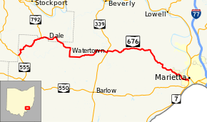
State Route 676 (SR 676) is a 26.53-mile (42.70 km) long east–west state highway in the southeastern portion of the U.S. state of Ohio. The western terminus of SR 676 is at a T-intersection with SR 555 approximately 3 miles (4.8 km) southeast of the village of Chesterhill. Its eastern terminus is at a T-intersection with SR 7 in the southwestern portion of the city of Marietta.
Route description
SR 676 traverses the western portion of Washington County and a small portion of southern Morgan County. There are no segments of SR 676 that are a part of the National Highway System (NHS), a network of route determined to be most important for the economy, mobility and defense of the country.[5]
History
The SR 676 designation was established in 1937. It has utilized the same routing between SR 555 near Chesterhill and SR 7 near Marietta throughout its history. Initially, the entire length of SR 676 was a gravel roadway.[3][4] In 1947, the easternmost stretch of SR 676 between County Road 183 (CR 183) and SR 7 was paved.[6][7] Four years later, the highway was hard-surfaced between the present SR 339 junction, at the time designated as SR 76, and CR 183.[8][9] The remaining gravel portion of SR 676 between SR 555 and the current SR 339 intersection was paved by 1961.[10][11]
Major intersections
| County | Location | mi[1][2] | km | Destinations | Notes | |||
|---|---|---|---|---|---|---|---|---|
| Washington | Wesley Township | 0.00 | 0.00 | SR 555 – Chesterhill, Bartlett | ||||
| 4.30 | 6.92 |  SR 792 north SR 792 north | Southern terminus of SR 792 | |||||
| Morgan |
No major junctions | |||||||
| Washington |
No major junctions | |||||||
| Morgan |
No major junctions | |||||||
| Washington | Watertown Township | 14.24 | 22.92 |  SR 339 south – Barlow SR 339 south – Barlow | Western end of SR 339 concurrency | |||
| 14.39 | 23.16 | SR 339 north / Franklin Street – Beverly | Eastern end of SR 339 concurrency | |||||
| Marietta | 26.40 | 42.49 | SR 7 (Fort Harmar Drive) – New Matamoras, Belpre, Athens | |||||
1.000 mi = 1.609 km; 1.000 km = 0.621 mi
| ||||||||
References
- 1 2 Ohio Department of Transportation. "Technical Services Straight Line Diagrams: SR 676, Washington County" (PDF). Retrieved 2011-05-25.
- 1 2 Ohio Department of Transportation. "Technical Services Straight Line Diagrams: SR 676, Morgan County" (PDF). Retrieved 2011-05-25.
- 1 2 Official Ohio Highway Map (MrSID) (Map). Cartography by ODOH. Ohio Department of Highways. 1936. Retrieved 2011-05-26.
- 1 2 Official Ohio Highway Map (MrSID) (Map). Cartography by ODOH. Ohio Department of Highways. 1937. Retrieved 2011-05-26.
- ↑ National Highway System: Ohio (PDF) (Map). Federal Highway Administration. December 2003. Retrieved 2011-05-27.
- ↑ Ohio Highway Map (MrSID) (Map). Cartography by ODOH. Ohio Department of Highways. 1946. Retrieved 2011-05-26.
- ↑ Ohio Highway Map (MrSID) (Map). Cartography by ODOH. Ohio Department of Highways. 1947. Retrieved 2011-05-26.
- ↑ Ohio Highway Map (MrSID) (Map). Cartography by ODOH. Ohio Department of Highways. 1950. Retrieved 2011-05-26.
- ↑ Ohio Highway Map (MrSID) (Map). Cartography by ODOH. Ohio Department of Highways. 1951. Retrieved 2011-05-26.
- ↑ Ohio Highway Map (MrSID) (Map). Cartography by ODOH. Ohio Department of Highways. 1959. Retrieved 2011-05-26.
- ↑ Ohio Highway Map (MrSID) (Map). Cartography by ODOH. Ohio Department of Highways. 1961. Retrieved 2011-05-26.