Ohio State Route 84
| ||||
|---|---|---|---|---|
 | ||||
| Route information | ||||
| Maintained by ODOT | ||||
| Length: | 63.34 mi[1] (101.94 km) | |||
| Existed: | 1924 – present | |||
| Major junctions | ||||
| West end: |
  US 6 / US 20 in Euclid US 6 / US 20 in Euclid | |||
 I-90 in Wickliffe I-90 in Wickliffe I-90 / SR 193 near North Kingsville I-90 / SR 193 near North Kingsville | ||||
| East end: |
 PA 226 near Conneaut PA 226 near Conneaut | |||
| Location | ||||
| Counties: | Cuyahoga, Lake, Ashtabula | |||
| Highway system | ||||
| ||||


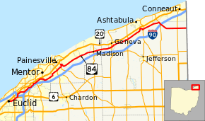
State Route 84 (SR 84) is an east–west state highway in the northeastern portion of the U.S. state of Ohio. Its western terminus is along US 6 at US 20 in Euclid, and its eastern terminus is at the Pennsylvania state line about 10 miles (16 km) south-southeast of Conneaut; Pennsylvania Route 226 continues eastward.
A portion of SR 84 runs along the historic Johnnycake Ridge Road.[2][3]
History
- 1923 – Original route established;[4] originally routed from 1-mile (1.6 km) south of Madison to 2 miles (3.2 km) west of Andover along the current alignment of State Route 307 from 1-mile (1.6 km) south of Madison to Dorset, and a currently unnumbered road from Dorset to West Andover.[5]
- 1926 – Extended to Willoughby Hills along a previously unnumbered road.[5]
- 1931 – Truncated at Dorset; Dorset to West Andover decertified.[5]
- 1935 – Rerouted from Madison to Ashtabula along the previous State Route 307 alignment (which was unnumbered before 1933); former alignment from south of Madison to Dorset certified as State Route 307.[5]
- 1938 – Extended to Pennsylvania state line along the former alignment of State Route 83 from Ashtabula to Kelloggsville (which was unnumbered before 1926), and along a previously unnumbered road from Kelloggsville to the state line.[5]
Major junctions
| County | Location | mi[1] | km | Destinations | Notes |
|---|---|---|---|---|---|
| Cuyahoga | Euclid | 0.00 | 0.00 | US 6 west / US 20 (Euclid Avenue) | Western end of US 6 concurrency |
| Richmond Heights | 2.20 | 3.54 |  SR 175 (Richmond Road) SR 175 (Richmond Road) | ||
| Lake | Willoughby Hills | 3.28 | 5.28 | US 6 east (Chardon Road) / Bishop Road | Eastern end of US 6 concurrency |
| Wickliffe | 3.67 | 5.91 |   I-90 to I-271 south / SR 2 – Erie, PA, Columbus, Cleveland, Painesville I-90 to I-271 south / SR 2 – Erie, PA, Columbus, Cleveland, Painesville | Exit 187 (I-90) | |
| Willoughby | 6.46 | 10.40 |  SR 91 (S.O.M. Center Road) SR 91 (S.O.M. Center Road) | ||
| 8.35 | 13.44 |  SR 174 south (River Road) / Willoughcroft Road SR 174 south (River Road) / Willoughcroft Road | Western end of SR 174 concurrency | ||
| 8.69 | 13.99 | SR 174 north (Rigde Road) / Oakdale Avenue | Eastern end of SR 174 concurrency | ||
| Mentor | 10.99 | 17.69 |  SR 306 (Broadmoor Road) to I-90 SR 306 (Broadmoor Road) to I-90 | ||
| 13.19 | 21.23 |  SR 615 (Center Street) to I-90 SR 615 (Center Street) to I-90 | |||
| Concord Township | 18.98 | 30.55 |  SR 44 to I-90 / SR 2 – Chardon, Painesville SR 44 to I-90 / SR 2 – Chardon, Painesville | Interchange | |
| Painesville | 20.53 | 33.04 |  SR 86 east (Painesville Warren Road) SR 86 east (Painesville Warren Road) | Western end of SR 86 concurrency | |
| 21.33 | 34.33 | SR 86 west (South State Street) / East Walnut Avenue | Eastern end of SR 86 concurrency | ||
| Madison | 32.31 | 52.00 |  SR 528 south (River Street) to I-90 SR 528 south (River Street) to I-90 | Western end of SR 528 concurrency | |
| 32.26 | 51.92 | SR 528 north (Lake Street) | Eastern end of SR 528 concurrency | ||
| Ashtabula | Geneva | 37.79 | 60.82 |  SR 534 SR 534 | |
| Saybrook Township | 43.44 | 69.91 |  SR 45 – Rock Creek SR 45 – Rock Creek | ||
| Ashtabula Township | 49.53 | 79.71 |  SR 11 to I-90 – Youngstown SR 11 to I-90 – Youngstown | Interchange | |
| Kingsville Township | 54.53 | 87.76 | SR 193 north / East Main Street – North Kingsville | Western end of SR 193 concurrency | |
| 55.17– 55.45 | 88.79– 89.24 | I-90 – Cleveland, Erie, PA | Exit 235 (I-90) | ||
| 55.38 | 89.13 | SR 193 south | Eastern end of SR 193 concurrency | ||
| Monroe Township | 60.60 | 97.53 |  SR 7 – Andover, Conneaut SR 7 – Andover, Conneaut | ||
| 63.34 | 101.94 | PA 226 east – Albion | Pennsylvania state line | ||
1.000 mi = 1.609 km; 1.000 km = 0.621 mi
| |||||
References
- 1 2 "Division of Planning - Office of Technical Services - Destape files". ODOT. July 16, 2013. Retrieved February 15, 2014 — Cuyahoga County, Lake County, Ashtabula County
- ↑ Ohio Department of Transportation. "Technical Services Straight Line Diagrams". Retrieved April 30, 2010.
- ↑ Sartin, V. David (2007-08-31). "Johnnycake Ridge Road -- 3 different versions of its origin". PD Extra. Retrieved 2008-03-31.
- ↑ Explanation of the Ohio State Highway System (The Unofficial Ohio State Highways Web Site) by John Simpson Archived May 23, 2006, at the Wayback Machine.
- 1 2 3 4 5 Route 84 (The Unofficial Ohio State Highways Web Site) by John Simpson Archived December 25, 2004, at the Wayback Machine.
This article is issued from Wikipedia - version of the 11/19/2016. The text is available under the Creative Commons Attribution/Share Alike but additional terms may apply for the media files.