2011 Lake Champlain and Richelieu River floods
 Lake Champlain and the Richelieu River basin | |
| Date | April 2011 – End June |
|---|---|
| Location |
New York Quebec (Montérégie) Vermont |
| Deaths | None |
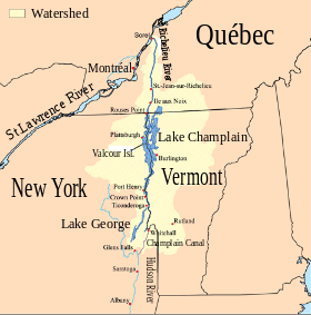
The 2011 Lake Champlain and Richelieu River floods were a series of water level increases that began at the end of April 2011 and caused a subsequent overflow of the Richelieu River in Canada and Lake Champlain in the United States.[1] The flooding occurred due to record snowfall in the area followed by its snowmelt and in combination with intense spring rains.[2] Lake Champlain stayed at flood stage for 67 days from April to June, and on May 10, 2011, the lake broke its previous flood level set in 1869 by reaching 102.8 ft. at Rouses Point, Vermont.[2][3] The floods affected about 3,000 homes in Montérégie[4][5] and caused an estimated six million U.S. dollars of damage in seven counties in the northern area of Vermont.[6][7] The damage was so bad that a state of emergency was declared by Vermont on May 5, 2011.[8] Similar damage was reported in New York State.
In Quebec, the major cities affected by the flooding were Venise-en-Quebec, Noyan, Saint-Jean-sur-Richelieu, Henryville, Saint-Paul-de-l'Île-aux-Noix, and Sainte-Anne-de-Sabrevois.[9] Citizens of Quebec were supplied with safe drinking water by the government due to the prolonged period of time in which the city's water supplies were likely contaminated.[2] On May 5, the Canadian Forces were requested to help evacuate residents and build dikes to try to protect areas at risk.
Operation Lotus
Operation Lotus was the name of the military operation that assisted citizens in the Montérégie area in response to a formal request for assistance from the province of Quebec as a result of this natural disaster.[10] The Canadian Forces worked to limit the damage caused by the worst floods to occur in the valley of the Richelieu River and on Lake Champlain over the previous 150 years.[11] Over 650 Canadian soldiers and sailors participated at one time or another in Operation Lotus until it ended on June 17.[12]
References
- ↑ Medalie, L. and S.A. Olson (2013). High-water Marks from Flooding in Lake Champlain from April through June 2011 and Tropical Storm Irene in August 2011 in Vermont. Reston, Va.: U.S. Department of the Interior, U.S. Geological Survey.
- 1 2 3 Castle, Stephanie (2013). "Flood Resilience in the Lake Champlain Basin and Upper Richelieu River" (PDF). Lake Champlain Basin Program. Retrieved November 18, 2016.
- ↑ "Flooding along the Richelieu River, Quebec". Nasa.gov. May 2011. Retrieved November 17, 2016.
- ↑ Lévesque, Lia; St-Arnaud, Pierre; La Presse canadienne (May 6, 2011), L'armée se déploie en Montérégie » selon Jean Charest (in French), La Tribune (Sherbrooke)
- ↑ Inondations en Montérégie : l'eau monte encore plus (in French), Radio-Canada, May 5, 2011, retrieved May 9, 2011
- ↑ Jack Thurston (May 10, 2011). "FEMA teams assess Vermont flooding". NECN.com. Retrieved May 15, 2011.
- ↑ Sue Minter (May 13, 2011). "Lake Champlain flood damage estimates for roads and bridges top $6 million". Communiqué de presse. VTDigger.org. Retrieved May 15, 2011.
- ↑ Bjerklie, David (2014). "Assessment of the Spatial Extent and Height of Flooding in Lake Champlain During May 2011, Using Satellite Remote Sensing and Ground-Based Information" (PDF). USGS. Retrieved November 18, 2016.
- ↑ "Inondations en Montérégie : l'armée à l'œuvre, Charest sur le terrain" (in French). Radio Canada. May 5, 2011. Retrieved May 13, 2011.
- ↑ "Military aids weary Que. flood victims". CBC News. May 5, 2011.
- ↑ "Inondations en Montérégie : déploiement de l'armée et visite de Jean Charest" (in French). May 5, 2011.
- ↑ "The Government Of Canada And The Canadian Forces Assist Those Affected By Flooding In The Province Of Quebec". May 5, 2011.
| Wikimedia Commons has media related to Flooding of the Lake Champlain basin and Richelieu River in 2011. |