Ordsall, Nottinghamshire
| Ordsall | |
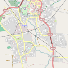
 Modern map of Ordsall |
|
 Ordsall |
|
| Population | 14,194 (Ward 2011) |
|---|---|
| District | Bassetlaw |
| Shire county | Nottinghamshire |
| Region | East Midlands |
| Country | England |
| Sovereign state | United Kingdom |
| Dialling code | 01777 |
| Police | Nottinghamshire |
| Fire | Nottinghamshire |
| Ambulance | East Midlands |
| EU Parliament | East Midlands |
|
|
Coordinates: 53°19′N 0°57′W / 53.31°N 0.95°W
The village of Ordsall is attached to the market town of Retford, Nottinghamshire, England, formally known as East Retford. The Bassetlaw ward of the same name had a population of 14,194 at the 2011 census.[1]
All Hallows' Church, Ordsall serves the village and is situated beside the River Idle at the south side of Ordsall, an area sometimes referred to as "Old Ordsall". The River Idle, along with the Great Northern Rail Line, divides Ordsall from Retford.
Ordsall is served by Ordsall Primary School, which is on Ordsall Road and from the age of 11 school children have the option of going to one of Retford's two secondary schools, Retford Oaks High School or Elizabethen High School.
The football team 'Ordsall Rangers' is the village football team.
History
There is no record of Ordsall before the days of William the Conqueror, when the land was chiefly marsh. In the Domesday Book of 1086, the name of the village is Ordeshale and in other early documents the name was Ordesale. In 1637 it was even printed on a map as Ardsall, however these corruptions of names are usual everywhere.
For centuries the parish of Ordsall consisted of the village and two small hamlets, Thrumpton and Whitehouses. Ordsall Parish became part of the Retford Area Team Ministry, the area covered by the former Retford Deanery, in April 2011. The ecclesiastical parish of Ordsall covers a much larger area than Ordsall village. Whereas the village is bounded by the river and railway lines, the parish extends northwards towards the centre of East Retford as far as Albert Road.
The ancient parish became a civil parish in 1866, but in 1921 the civil parish was abolished and absorbed into the Municipal Borough of East Retford.[2]
Population
The population of the Parish, which includes the village of Ordsall and surrounding areas such as Thrumpton. The 2001 population is the population of the village alone.
| Year | Population |
|---|---|
| 1801 | 560 |
| 1811 | 599 |
| 1821 | 632 |
| 1831 | 809 |
| 1841 | 955 |
| 1851 | 1,342 |
| 1881 | 3,011 |
| 1891 | 3,852 |
| 1901 | 5,199 |
| 1911 | 5,690 |
| 2001 | 4,328 |
| 2011 | 4,215 |
References
- ↑ "Bassetlaw ward population 2011". Neighbourhood Statistics. Office for National Statistics. Retrieved 13 April 2016.
- ↑ Vision of Britain website
External links
![]() Media related to Ordsall, Nottinghamshire at Wikimedia Commons
Media related to Ordsall, Nottinghamshire at Wikimedia Commons