Pamisos
For other uses, see Pamisos (disambiguation).
| Pamisos Πάμισος | |
|---|---|
  Pamisos | |
|
Location within the regional unit 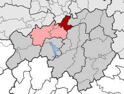 | |
| Coordinates: 39°28′N 21°51′E / 39.467°N 21.850°ECoordinates: 39°28′N 21°51′E / 39.467°N 21.850°E | |
| Country | Greece |
| Administrative region | Thessaly |
| Regional unit | Karditsa |
| Municipality | Mouzaki |
| • Municipal unit | 53.9 km2 (20.8 sq mi) |
| Population (2011)[1] | |
| • Municipal unit | 3,787 |
| • Municipal unit density | 70/km2 (180/sq mi) |
| Time zone | EET (UTC+2) |
| • Summer (DST) | EEST (UTC+3) |
| Vehicle registration | ΚΑ |
Pamisos (Greek: Πάμισος) is a former municipality in the Karditsa regional unit, Thessaly, Greece. Since the 2011 local government reform it is part of the municipality Mouzaki, of which it is a municipal unit.[2] The municipal unit has an area of 53.854 km2.[3] Population 3,787 (2011). The seat of the municipality was in Agnantero.
References
- ↑ "Απογραφή Πληθυσμού - Κατοικιών 2011. ΜΟΝΙΜΟΣ Πληθυσμός" (in Greek). Hellenic Statistical Authority.
- ↑ Kallikratis law Greece Ministry of Interior (Greek)
- ↑ "Population & housing census 2001 (incl. area and average elevation)" (PDF) (in Greek). National Statistical Service of Greece.
This article is issued from Wikipedia - version of the 12/2/2016. The text is available under the Creative Commons Attribution/Share Alike but additional terms may apply for the media files.