Paul Revere Park

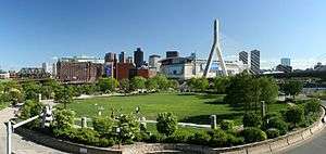
Paul Revere Park is a 5-acre (2.0 ha) park located on the Charles River in Charlestown, Massachusetts.[1] The park was the first park to open along the "Lost Half Mile" of the Charles River as mitigation for the taking of planned parkland for the construction of the Big Dig.[2] The park runs along the Charles River between the Freedom Trail on North Washington Street and the Leonard P. Zakim Bunker Hill Memorial Bridge. The park features a large oval-shaped lawn, an informal performance area, and a playground.[3][4]
The park first opened in 1999,[3] although the upstream portions of the park were used as a staging area for the construction of the Zakim Bridge and did not open until 2007.[4] A 690-foot pedestrian bridge under the Zakim Bridge and over the MBTA railroad tracks leading into North Station opened in 2012, connecting the park to North Point Park in Cambridge, Massachusetts.[5]
References
| Wikimedia Commons has media related to Paul Revere Park. |
- ↑ "Places To Go...: Charlestown: Paul Revere Park". The Boston Harborwalk. Archived from the original on July 9, 2015. Retrieved May 5, 2014.
- ↑ Berdik, Chris (November 16, 2003). "Along the Lost Half-Mile, a Process of Rediscovery". Boston Globe.
A short walk through more construction, steel beams, and concrete barriers brings the group to Lovejoy Wharf and the ferry terminal, where they turn left and proceed along a walkway that zigzags across the river's locks into Charlestown and the first section of the lost half-mile to be officially found again, Paul Revere Park, which opened in July 1999.
- 1 2 Todisco, Patrice (July 8, 2012). "New Charles River Basin Parks : North Point + Nashua Street + Paul Revere". Landscape Notes. Retrieved May 5, 2014.
- 1 2 Smith, Cynthia; Uhlig, Bob. "Paul Revere Park | The Landscape Architect's Guide to Boston". American Society of Landscape Architects. Retrieved May 5, 2014.
- ↑ Conti, Matt (July 14, 2012). "New Pedestrian Bridge Makes for Easy Walk or Bike to Cambridge". NorthEndWaterfront.com. Retrieved May 5, 2014.
Coordinates: 42°22′12″N 71°03′45″W / 42.37000°N 71.06250°W