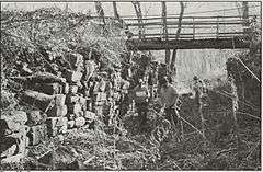
Pennsylvania Canal Guard Lock and Feeder Dam, Raystown Branch
|
Pennsylvania Canal Guard Lock and Feeder Dam, Raystown Branch | |
|
HABS/HAER photo c. 1991 | |
  | |
| Location | 2.5 mi. E of Huntingdon, S of US 22 on the Juniata River, Henderson Township, Pennsylvania |
|---|---|
| Coordinates | 40°26′59″N 77°58′09″W / 40.44972°N 77.96917°WCoordinates: 40°26′59″N 77°58′09″W / 40.44972°N 77.96917°W |
| Area | 2 acres (0.81 ha) |
| Built | 1831 |
| MPS | Industrial Resources of Huntingdon County, 1780--1939 MPS |
| NRHP Reference # | 90000394[1] |
| Added to NRHP | March 20, 1990 |
Pennsylvania Canal Guard Lock and Feeder Dam, Raystown Branch, also known as the Raystown Branch Feeder Canal, is a historic canal structure located at Henderson Township in Huntingdon County, Pennsylvania. The property includes the remains of a guard lock and feeder dam. The guard lock was built in 1831, and the remains consist of two 90-foot long parallel walls, 8-feet high and 15-feet apart. The remains of the feeder dam consist of stone and earth remnants of a dam that once stretched across the Juniata River. The lock and dam were built to allow boats built on Standing Stone Creek to enter the Pennsylvania Canal. The lock and dam were abandoned with the rest of the Pennsylvania Canal in the 1870s.[2]
It was listed on the National Register of Historic Places in 1990.[1]
References
- 1 2 National Park Service (2010-07-09). "National Register Information System". National Register of Historic Places. National Park Service.
- ↑ "National Historic Landmarks & National Register of Historic Places in Pennsylvania" (Searchable database). CRGIS: Cultural Resources Geographic Information System. Note: This includes Deborah L. Suciu (September 1989). "National Register of Historic Places Inventory Nomination Form: Pennsylvania Canal Guard Lock and Feeder Dam, Raystown Branch" (PDF). Retrieved 2011-12-01.


