Penola Strait
Penola Strait
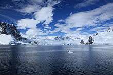
Penola Strait (65°10′S 64°7′W / 65.167°S 64.117°WCoordinates: 65°10′S 64°7′W / 65.167°S 64.117°W) is a strait 11 nautical miles (20 km) long and averaging 2 nautical miles (3.7 km) wide, separating the Argentine Islands, Petermann Island and Hovgaard Island from the west coast of Graham Land. Traversed by the Belgian Antarctic Expedition under Gerlache on February 12, 1898. Named by the British Graham Land Expedition (BGLE), 1934–37, under Rymill, for the expedition ship Penola.
![]() This article incorporates public domain material from the United States Geological Survey document "Penola Strait" (content from the Geographic Names Information System).
This article incorporates public domain material from the United States Geological Survey document "Penola Strait" (content from the Geographic Names Information System).
This article is issued from Wikipedia - version of the 11/21/2015. The text is available under the Creative Commons Attribution/Share Alike but additional terms may apply for the media files.