Petit Vignemale
| Petit Vignemale | |
|---|---|
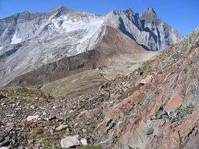 Petit Vignemale (3032 m) au centre, col de la Hourquette d'Ossoue à droite (2 734 m), vue partielle du glacier d'Ossoue (Photo prise du col de Labas) | |
| Highest point | |
| Elevation | 3,032 m (9,948 ft) |
| Listing | List of Pyrenean three-thousanders |
| Coordinates | 42°46′29″N 0°08′05″E / 42.77472°N 0.13472°ECoordinates: 42°46′29″N 0°08′05″E / 42.77472°N 0.13472°E [1] |
| Geography | |
  Petit Vignemale Location in the Pyrenees | |
| Location | Hautes-Pyrénées, France |
| Parent range | Massif du Vignemale (Pyrenees) |
| Geology | |
| Age of rock | Praguien - Emsien[2] |
The Petit Vignemale is a summit in the French Pyrenees in the massif du Vignemale. Access is possible either by the Gaube valley (beyond Cauterêts), or la vallée d'Ossoue.
Toponymy
Vignemale is a tautological compound of two pre-Indo-European vin and mal both meaning « mountain ».[3]
Geography
Le Petit Vignemale is located in the Hautes-Pyrénées department, near Cauterets and Gavarnie arrondissement of Argelès-Gazost in the Pyrenees National Park.
Geology
The summit is composed of sediment masses from the early Devonian period.[4]
Climbing
The first ascent was made in August 1798 by La Baumelle.
- Access
Two routes :
- normal route (hiking) ;
- north harbor (climbing).
References
- ↑ Coordinates verified via WikiMapia
- ↑ Source : cartes géologiques à l'échelle 1:50000 du Bureau de recherches géologiques et minières (site en ligne).
- ↑ Albert Dauzat et al. Dictionnaire étymologique des noms de rivières et de montagnes en France, Lille, Editions Klincksieck, 1982
- ↑ Source : cartes géologiques à l'échelle 1:50000 du Bureau de recherches géologiques et minières (site en ligne).
This article is issued from Wikipedia - version of the 8/1/2016. The text is available under the Creative Commons Attribution/Share Alike but additional terms may apply for the media files.