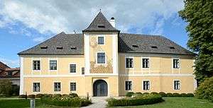
Petzenkirchen

| Petzenkirchen | ||
|---|---|---|
| ||
 Petzenkirchen Location within Austria | ||
| Coordinates: 48°9′N 15°9′E / 48.150°N 15.150°ECoordinates: 48°9′N 15°9′E / 48.150°N 15.150°E | ||
| Country | Austria | |
| State | Lower Austria | |
| District | Melk | |
| Government | ||
| • Mayor | Lisbeth Kern | |
| Area | ||
| • Total | 2.89 km2 (1.12 sq mi) | |
| Elevation | 258 m (846 ft) | |
| Population (1 January 2016)[1] | ||
| • Total | 1,301 | |
| • Density | 450/km2 (1,200/sq mi) | |
| Time zone | CET (UTC+1) | |
| • Summer (DST) | CEST (UTC+2) | |
| Postal code | 3252 | |
| Area code | 07416 | |
| Website | www.petzenkirchen.at | |
Petzenkirchen is a market town in the district of Melk in the Austrian state of Lower Austria.
Population
| Historical population | ||
|---|---|---|
| Year | Pop. | ±% |
| 1971 | 1,098 | — |
| 1981 | 1,163 | +5.9% |
| 1991 | 1,177 | +1.2% |
| 2001 | 1,296 | +10.1% |
Geography
Petzenkirchen is located in the Mostviertel which is part of Lower Austria. The area of the market town is 2.89 square kilometres. Adjacent municipalities are the town of Wieselburg and the village of Bergland.
References
This article is issued from Wikipedia - version of the 11/4/2014. The text is available under the Creative Commons Attribution/Share Alike but additional terms may apply for the media files.
