Pietralata (Rome)
| Pietralata | |
|---|---|
| District of Rome | |
|
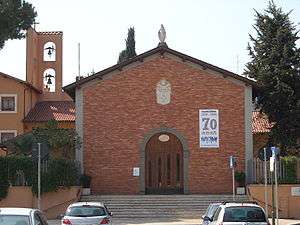
St Michael archangel's church in Pietralata | |
| Coordinates: 41°54′55″N 12°33′20″E / 41.91528°N 12.55556°ECoordinates: 41°54′55″N 12°33′20″E / 41.91528°N 12.55556°E | |
| Country | Italy |
| Region | Lazio |
| City | Rome |
| Area | |
| • Total | 5.9655 km2 (2.3033 sq mi) |
Pietralata is the 21st quarter of Rome. It is part of the Municipio IV. Its name comes from the Latin Prata Lata[1] meaning large fields, which is possibly a reference to the large amount of nature and vegetation present.
Monuments and important places
Civil buildings
- Film Studios ex De Paolis,[2] In Via Tiburtina. 41°54′32″N 12°32′28″E / 41.908830°N 12.541110°E, the building was kept to the mafia and re-used for social works.[3]
Religious buildings
- St Michael archangel's church in Pietralata, in Largo Geltrude Comensoli. 41°55′04″N 12°33′01″E / 41.917764°N 12.550236°E
- Saint Athanasius' church a Via Tiburtina, in Via Achille Benedetti. 41°54′45″N 12°32′36″E / 41.912479°N 12.543444°E
- Saint Romano martyr's church, in Largo Antonio Beltramelli.
- Saint Fidelis of Sigmaringen's church, in Via Mesula. 41°55′33″N 12°32′04″E / 41.925715°N 12.534548°E
- Madonna delle Grazie's chapel, in Via di Vigna Mangani.[4]
- Saint Vincent Pallotti's church, in Via Matteo Tondi, from 1993.
- Parrocchia eretta il 1º gennaio 1978 con il decreto del cardinale vicario Ugo Poletti "Succrescente in dies". Il territorio è stato desunto da quello delle parrocchie di S. Maria del Soccorso e di S. Michele Arcangelo a Pietralata.
Military buildings
- Forte Pietralata, in Via del Forte di Pietralata. 41°55′32″N 12°33′01″E / 41.925653°N 12.550356°E, it's the See of (Granatieri di Sardegna Mechanized Brigade).
School buildings
- Scuola statale materna ed elementare Andrea Torre
- Scuola statale materna ed elementare Vittorio Veneto
- Scuola statale media Pasquale Villari
- Istituto Tecnico Industriale di Stato Antonio Meucci
- Istituto Tecnico Industriale di Stato Joseph-Louis Lagrange
See also
- Pietralata's Mass Murder, 23 October 1943
References
- ↑ Orietta Verdi, Francesca Curti e Stefania Piersanti (a cura di), In presentia mei notarii. Piante e disegni nei protocolli dei Notai Capitolini (1605–1875), Roma, Ministero per i beni e le attività culturali, Direzione generale per gli archivi, 2009, ISBN 978-88-7125-306-0
- ↑
Studios
— Stabilimenti Cinematografici e Multimediali. - ↑
Roma Capitale
— Da Bene Confiscato a Bene Comune. - ↑ Photo of the chapel on Flickr
External links
| Wikimedia Commons has media related to Pietralata. |
This article is issued from Wikipedia - version of the 1/3/2016. The text is available under the Creative Commons Attribution/Share Alike but additional terms may apply for the media files.