Plymouth Historic District (Plymouth, New Hampshire)
|
Plymouth Historic District | |
|
The Plymouth Green | |
  | |
| Location | Bounded by Court, Main, and Highland Sts., Plymouth, New Hampshire |
|---|---|
| Coordinates | 43°45′26″N 71°41′17″W / 43.75722°N 71.68806°WCoordinates: 43°45′26″N 71°41′17″W / 43.75722°N 71.68806°W |
| Area | 2 acres (0.81 ha) |
| Architect | Damon Brothers |
| Architectural style | Romanesque |
| NRHP Reference # | 86000343[1] |
| Added to NRHP | March 14, 1986 |
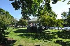
The Plymouth Historic District encompasses a cluster of five civic buildings (of which four contribute to the district's significance) and the town common of Plymouth, New Hampshire. The 2-acre (0.81 ha) district includes the town hall/court house, the Pemigewasset National Bank building, and the US Post Office building, as well as the Old Grafton County Courthouse (now a local history museum). The Plymouth Congregation Church also falls within the district bounds, but is not considered contributing. The buildings are arrayed on the west side of Plymouth's town common, an oval grassy area flanked by one-way sections of Main Street.[2]
The district was listed on the National Register of Historic Places in 1986.[1]
See also
References
- 1 2 National Park Service (2010-07-09). "National Register Information System". National Register of Historic Places. National Park Service.
- ↑ "NRHP nomination for Plymouth Historic District" (PDF). National Park Service. Retrieved 2014-04-20.
| Topics |  | |
|---|---|---|
| Lists by county | ||
| Other lists | ||
| ||
This article is issued from Wikipedia - version of the 11/30/2016. The text is available under the Creative Commons Attribution/Share Alike but additional terms may apply for the media files.