Po Toi Islands


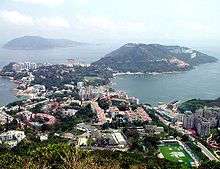
The Po Toi Islands (Chinese: 蒲台羣島, originally 蒲苔羣島) are a small group of islands with a population of around 200, south-east of Hong Kong Island, off Stanley, in Hong Kong. The main island of the group is Po Toi Island. Administratively, they are part of Islands District.[1]
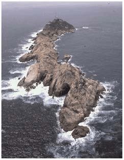
The islands are notable for interesting rock formations and open-air seafood restaurants. Po Toi Island has a "haunted house", and some rock carvings supposed to be the epitaph of an emperor who died on or near Po Toi. Waglan Island has one of the five surviving pre-war lighthouses in Hong Kong.[2]
Geography
Po Toi Islands include:
- Castle Rock (螺洲白排)
- Lo Chau (螺洲, Beaufort Island)
- Mat Chau (墨洲), an islet off Po Toi island
- Mat Chau Pai (墨洲排), an islet off Mat Chau
- Po Toi Island (蒲台島, originally 蒲苔島) - 3.69 km²
- Sai Pai (細排)
- San Pai (散排)
- Sung Kong (宋崗)
- Tai Pai (大排)
- Waglan Island (橫瀾島)
Name
For the origin of the name, see Po Toi.
Transport
The islands are accessible by private ferry (kai-to) or water taxi. Scheduled ferries connect Po Toi island with Aberdeen and Stanley.[3]
See also
References
External links
| Wikimedia Commons has media related to Po Toi Islands. |
Coordinates: 22°10′27″N 114°16′14″E / 22.1742°N 114.2705°E