Point La Nim, New Brunswick
| Point La Nim | |
|---|---|
| Unincorporated community | |
 Point La Nim Location within New Brunswick. | |
| Coordinates: 48°04′N 66°27′W / 48.06°N 66.45°WCoordinates: 48°04′N 66°27′W / 48.06°N 66.45°W | |
| Country |
|
| Province |
|
| County | Restigouche |
| Parish | Dalhousie |
| Electoral Districts Federal |
Madawaska—Restigouche |
| Provincial | Dalhousie-Restigouche East |
| Government | |
| • Type | Local service district |
| Time zone | AST (UTC-4) |
| • Summer (DST) | ADT (UTC-3) |
| Postal code(s) | E3N |
| Area code(s) | 506 |
| Highways |
|
Point La Nim (2001 pop.: approx. 350) is an unincorporated community in Restigouche County, New Brunswick, Canada.[1]
The community is located on the Restigouche River immediately upstream (west) from the town of Dalhousie. Its name was taken from Mi'kmaq name "ananimkik" which translates to "lookout place". Located west of Dalhousie. Point La Nim's post office was originally called "Point La Nin" in 1855. It was renamed Point La Nim in 1862.
History
Notable people
Main article: List of people from Restigouche County, New Brunswick
See also
References
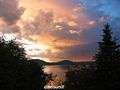 Point La Nim / Restigouche River - summer
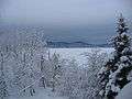 Point La Nim / Restigouche River - winter
 |
Restigouche River | | ||
| Dalhousie Junction | |
McNeish | ||
| ||||
| | ||||
| Eel River Crossing |
This article is issued from Wikipedia - version of the 8/13/2015. The text is available under the Creative Commons Attribution/Share Alike but additional terms may apply for the media files.