Polly Dome
| Polly Dome | |
|---|---|
 180° panorama of southeast side of Polly Dome viewed from Pywiack Dome | |
| Highest point | |
| Elevation | 9,806[1] ft (2,989 m) NAVD 88 |
| Prominence | 1,086 ft (331 m) [1] |
| Coordinates | 37°51′15″N 119°27′0″W / 37.85417°N 119.45000°WCoordinates: 37°51′15″N 119°27′0″W / 37.85417°N 119.45000°W [2][3] |
| Geography | |
 Polly Dome  Polly Dome Location of Polly Dome in California | |
| Location | Yosemite National Park, Mariposa County, California, U.S. |
| Parent range | Sierra Nevada |
| Topo map | USGS Tenaya Lake |
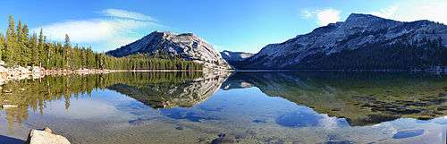
Panorama at Tenaya Lake: Polly Dome with its south-west peak called Stately Pleasure Dome is prominent center-left
Polly Dome is a prominent 1,640 feet (500 m) foot granite dome on the northwest side of Tenaya Lake and Tioga Road in Yosemite high country. The dome is over 2 miles long and has forested north and west slopes. Southeast portion of the dome, known as Stately Pleasure Dome consist of glaciated and exfoliated bare granite rock. The summit has unobstructed views east to the Cathedral Range, northwest over the Grand Canyon of the Tuolumne and north over Tuolumne Meadows to the Sierra crest.[3]
References
- 1 2 "Polly Dome, California". Peakbagger.com. Retrieved 2016-01-21.
- ↑ "Polly Dome". Geographic Names Information System. United States Geological Survey. Retrieved 2016-01-21.
- 1 2 "Polly Dome". SummitPost.org. Retrieved 2016-01-21.
This article is issued from Wikipedia - version of the 10/15/2016. The text is available under the Creative Commons Attribution/Share Alike but additional terms may apply for the media files.