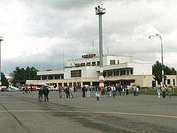
Poprad–Tatry Airport
| Poprad–Tatry Airport Letisko Poprad-Tatry | |||||||||||||||||||
|---|---|---|---|---|---|---|---|---|---|---|---|---|---|---|---|---|---|---|---|
 | |||||||||||||||||||
| IATA: TAT – ICAO: LZTT | |||||||||||||||||||
| Summary | |||||||||||||||||||
| Airport type | Public | ||||||||||||||||||
| Serves | Poprad, Slovakia | ||||||||||||||||||
| Elevation AMSL | 2,356 ft / 718 m | ||||||||||||||||||
| Coordinates | 49°04′25″N 20°14′28″E / 49.07361°N 20.24111°E | ||||||||||||||||||
| Website | airport-poprad.sk | ||||||||||||||||||
| Map | |||||||||||||||||||
 TAT Location of airport in Slovakia | |||||||||||||||||||
| Runways | |||||||||||||||||||
| |||||||||||||||||||
Poprad–Tatry Airport (Slovak: Letisko Poprad-Tatry) (IATA: TAT, ICAO: LZTT), is an airport in the Slovak ski resort town of Poprad. It is an airport with one of the highest elevations in Central Europe, at 718 m, which is 150 m higher than Innsbruck Airport in Austria, and 989 m lower than Samedan Airport in Switzerland (which has no scheduled flights).
Airlines and destinations
The airport serves schedule and charter airline operations, is a base for search and rescue air services, and handles general aviation. It does not offer any domestic flights. Charter flights are mainly operated in winter to destinations in Ukraine and Russia. Medical flights, VIP flights, ad hoc charters and ACMI flight also operate from the airport.
| Airlines | Destinations |
|---|---|
| Adria Airways | Seasonal charter: Tirana |
| airBaltic | Seasonal: Riga (begins 17 December 2016)[1] |
| Bulgarian Air Charter | Seasonal charter: Burgas |
| Neos | Seasonal charter: Tel Aviv |
| Travel Service Slovakia | Seasonal charter: Antalya, Araxos, Burgas |
| Wizz Air | London–Luton |
Statistics
Passenger throughput and operations since 2014:
| Year | Passengers | Change | Cargo (tonnes) |
|---|---|---|---|
| 2014[2] | 31,209 | ||
| 2015[3] | 85,100 | +172.7% | |
References
External links
![]() Media related to Letisko Poprad-Tatry at Wikimedia Commons
Media related to Letisko Poprad-Tatry at Wikimedia Commons
- Poprad–Tatry Airport (official site, English version)
- Airport information for LZTT at World Aero Data. Data current as of October 2006.Source: DAFIF.
- Airport information for LZTT at Great Circle Mapper. Source: DAFIF (effective October 2006).
- Current weather for LZTT at NOAA/NWS
- Accident history for TAT at Aviation Safety Network