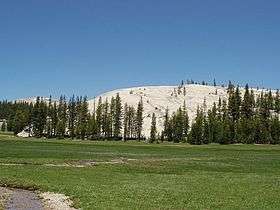
Pothole Dome
| Pothole Dome | |
|---|---|
 | |
| Highest point | |
| Elevation | 8765+ ft (2671+ m) NAVD 88[1] |
| Coordinates | 37°52′48″N 119°23′36″W / 37.8799245°N 119.3932138°WCoordinates: 37°52′48″N 119°23′36″W / 37.8799245°N 119.3932138°W [2] |
| Geography | |
| Location | Tuolumne County, California, U.S. |
| Parent range | Sierra Nevada |
| Topo map | USGS |
| Climbing | |
| Easiest route | Hide, class 1 |
Pothole Dome is a granite dome on the West side of Tuolumne Meadows, in Yosemite National Park.[1] The summit of the dome is easily accessible by foot from a parking area on the Tioga Road. The view from the summit includes most of Tuolumne Meadows and in the distance, Cathedral Peak.[3] The dome gives evidence of many of the geologic processes at work in Yosemite during and after the last ice age. In particular, the stranded, rounded boulders from a glacier that has long since retreated, and the water-eroded "potholes" provide evidence of two ways that water can interact with granite.[4]
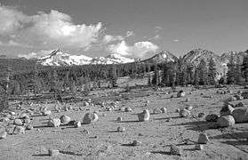 View from top of Pothole Dome |
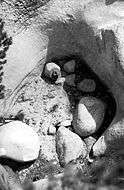 One of the potholes |
References
- 1 2 "Pothole Dome, California". Peakbagger.com. Retrieved 2014-01-19.
- ↑ "Pothole Dome". Geographic Names Information System. United States Geological Survey. Retrieved 2014-01-19.
- ↑ "Pothole Dome". SummitPost.org. Retrieved 2014-01-19.
- ↑ "Pothole Dome - Glacial Features". Groundspeak, Inc. Retrieved 2014-01-19.
External links
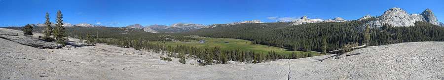
A panorama view from Pothole Dome
This article is issued from Wikipedia - version of the 5/10/2016. The text is available under the Creative Commons Attribution/Share Alike but additional terms may apply for the media files.