Primus Peak
| Primus Peak | |
|---|---|
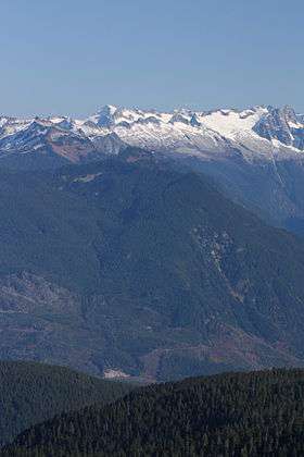 Primus Peak (left skyline with large shadowed northwest face); Austera Peak (indistinct ridge on skyline); Klawatti Peak (center skyline); Dorado Needle (far right skyline); Little Devil Peak (left middle distance) | |
| Highest point | |
| Elevation | 8,508 ft (2,593 m) [1] |
| Prominence | 828 ft (252 m) [1] |
| Coordinates | 48°34′55″N 120°05′28″W / 48.58194°N 120.09111°WCoordinates: 48°34′55″N 120°05′28″W / 48.58194°N 120.09111°W [2] |
| Geography | |
 Primus Peak | |
| Parent range | Cascade Range |
| Topo map | USGS Forbidden Peak |
Primus Peak (8,508 feet (2,593 m)) is located in North Cascades National Park in the U.S. state of Washington.[3] Primus Peak is flanked by North Klawatti Glacier to the south and Borealis Glacier to the northeast.
References
- 1 2 "Primus Peak, Washington". Peakbagger.com. Retrieved 2013-02-10.
- ↑ "Primus Peak". Geographic Names Information System. United States Geological Survey. Retrieved 2013-02-10.
- ↑ Forbidden Peak, WA (Map). TopoQwest (United States Geological Survey Maps). Retrieved 2013-02-10.
This article is issued from Wikipedia - version of the 2/24/2016. The text is available under the Creative Commons Attribution/Share Alike but additional terms may apply for the media files.