Qualibou
| Qualibou | |
|---|---|
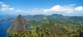 View from Gros Piton over the Qualibou caldera | |
| Highest point | |
| Elevation | 777 m (2,549 ft) [1] |
| Coordinates | 13°50′17″N 61°02′46″W / 13.838°N 61.046°W |
| Geography | |
| Location | Saint Lucia, Caribbean |
| Geology | |
| Age of rock | 32-39,000 years |
| Mountain type | Caldera[2] |
| Last eruption | 1766 |
| Climbing | |
| Easiest route |
active= no dormant= yes |
Qualibou, also known as the Soufrière Volcanic Centre is a 3.5 X 5 km wide caldera on the island of Saint Lucia that formed approximately 32-39,000 years ago. This eruption also formed the Choiseul Tuff which covers the south east portion of the island.
The Pitons are two large lava domes that formed 200-300,000 years ago, some time before the formation of the caldera and since then other domes have filled the caldera floor. More recently, there was a phreatic eruption in 1766 that deposited ash over a wide area.
Sulphur Springs is an active geothermal area located roughly in the centre of the caldera.
In 1990, 1999 and 2000 there were shallow depth volcanic earthquakes located 6 km ESE of the caldera.[3]
Gallery

 Petit Piton
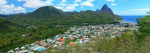 Soufrière and the Pitons
References
- ↑ This elevation is for Gros Piton, however Morne Gimie on the edge of the caldera has an elevation of 950m.
- ↑ Smithsonian Institution. "Qualibou".
- ↑ The University of the West Indies Seismic Research Centre (www.uwiseismic.com). "St Lucia".
This article is issued from Wikipedia - version of the 4/12/2013. The text is available under the Creative Commons Attribution/Share Alike but additional terms may apply for the media files.