Quebec Route 104
For the former Route 104, see Quebec Route 104 (pre-1970s).
| ||||
|---|---|---|---|---|
 | ||||
| Route information | ||||
| Maintained by Transports Québec | ||||
| Length: | 93.5 km[1] (58.1 mi) | |||
| Major junctions | ||||
| West end: |
| |||
|
| ||||
| East end: |
| |||
| Location | ||||
| Counties: | Roussillon / Le Haut-Richelieu / Brome-Missisquoi | |||
| Highway system | ||||
| ||||

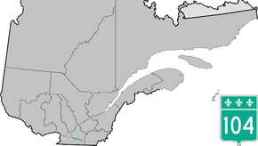
Route 104 is an east/west highway on the south shore of the St. Lawrence River. Its eastern terminus is in Knowlton at the junction of Route 243 and its western terminus is in La Prairie at the junction of Route 134.
Municipalities along Route 104
- La Prairie
- Saint-Jean-sur-Richelieu
- Mont-Saint-Grégoire
- Sainte-Brigide-d'Iberville
- Farnham
- Brigham
- Dunham
- Cowansville
- Brome Lake
Major intersections
| RCM or ET | Municipality | Km | Junction | Notes |
|---|---|---|---|---|
Western terminus of Route 104 | ||||
| Roussillon | La Prairie | 0.0 | 134 WEST: to Candiac 134 EAST: to Longueuil | |
| 2.7 | 30 WEST: to Vaudreuil-Dorion 30 EAST: to Sorel-Tracy | |||
| 2.7 | 217 SOUTH: to Saint-Philippe | |||
| Le Haut-Richelieu | Saint-Jean-sur-Richelieu | 10.7 | Chemin Grand-Pré | WEST: to L'Acadie |
| 18.8 | 35 NORTH: to Carignan | |||
| 19.9 | 219 SOUTH: to Saint-Cyprien-de-Napierville | |||
| 21.9 | 223 NORTH: to Chambly
223 SOUTH: to Saint-Blaise-sur-Richelieu | |||
| Félix-Gabriel-Marchand Bridge (Richelieu River) | ||||
| 23.5 | 133 NORTH: to Richelieu | |||
| 25.9 | 35/133 SOUTH: to Sainte-Anne-de-Sabrevois | |||
| Mont-Saint-Grégoire | 38.3 | 227 NORTH: to Marieville
227 SOUTH: to Saint-Alexandre | ||
| Brome-Missisquoi | Farnham | 28.2 | 233 NORTH: to Saint-Cesaire | |
| 49.9 51.9 |
235 NORTH: to Ange-Gardien 235 SOUTH: to Sainte-Sabine | |||
| Brigham | 60.2 | Chemin du Curé-Godbout | EAST: to Brigham | |
| Cowansville | 70.6 | 139 NORTH: to East Farnham | ||
| 73.3 | 202 WEST: to Dunham | |||
| 78.6 | 241 NORTH: to Brigham | |||
| Brome Lake | 81.3 | 139 SOUTH: to Sutton | ||
| 87.4 | 215 SOUTH: to Brome 215 NORTH: to Fulford | |||
| 93.6 | 243 SOUTH: to West Bolton 243 NORTH: to Shefford | |||
Eastern terminus of Route 104 | ||||
See also
References
- ↑ Ministère des transports, "Distances routières", page 55, Les Publications du Québec, 2005
External links
- Official Transport Quebec Road Map (Courtesy of the Quebec Ministry of Transportation) (French)
- Route 104 on Google Maps
This article is issued from Wikipedia - version of the 11/9/2016. The text is available under the Creative Commons Attribution/Share Alike but additional terms may apply for the media files.