Rabbit Hash Historic District
|
Rabbit Hash Historic District | |
 | |
  | |
| Location | 10021-10410 Lower River Rd., Rabbit Hash, Kentucky |
|---|---|
| Coordinates | 38°56′32″N 84°50′45″W / 38.94222°N 84.84583°WCoordinates: 38°56′32″N 84°50′45″W / 38.94222°N 84.84583°W |
| Area | 33 acres (13 ha) |
| Architect | Unknown |
| MPS | Boone County, Kentucky MPS |
| NRHP Reference # | 03001231[1] |
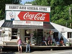
The Rabbit Hash Historic District in Rabbit Hash, Kentucky was added to the National Register of Historic Places on December 4, 2003. It includes 330 acres (1.3 km2), 12 buildings, 6 structures, and 3 objects around 10021-10410 Lower River Rd.[2][3] The Rabbit Hash General Store, one of the addresses in the District, had already been listed since February 2, 1989.[1]
References
- 1 2 National Park Service (2010-07-09). "National Register Information System". National Register of Historic Places. National Park Service.
- ↑ "National Register of Historic Places Listings December 12, 2003:". National Park Service. Retrieved 2008-08-24.
- ↑ "KENTUCKY - Boone County - Historic Districts". Retrieved 2008-08-24.
External links
- "Rabbit Hash," Chronicles of Boone County, Boone County Public Library (KY)
| Topics | |
|---|---|
| Lists by states |
|
| Lists by insular areas | |
| Lists by associated states | |
| Other areas | |
| |
This article is issued from Wikipedia - version of the 11/28/2016. The text is available under the Creative Commons Attribution/Share Alike but additional terms may apply for the media files.