Ragay, Camarines Sur
| Ragay | ||
|---|---|---|
| Municipality | ||
| ||
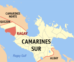 Map of Camarines Sur showing the location of Ragay | ||
.svg.png)  Ragay Location within the Philippines | ||
| Coordinates: 13°49′N 122°47′E / 13.82°N 122.78°ECoordinates: 13°49′N 122°47′E / 13.82°N 122.78°E | ||
| Country | Philippines | |
| Region | Bicol (Region V) | |
| Province | Camarines Sur | |
| District | 1st district (Riverside) | |
| Barangays | 38 | |
| Government[1] | ||
| • Mayor | Ricardo B. Aquino (Kampi) | |
| Area[2] | ||
| • Total | 400.22 km2 (154.53 sq mi) | |
| Population (2015 census)[3] | ||
| • Total | 58,214 | |
| • Density | 150/km2 (380/sq mi) | |
| Time zone | PST (UTC+8) | |
| ZIP code | 4410 | |
| IDD : area code | +63 (0)54 | |
| Income class | 1st class; partially urban | |
| Website |
ragay | |

Ragay is a first class municipality in the province of Camarines Sur, Philippines. According to the 2015 census, it has a population of 58,214 people.[3]
History
No date was known as to the establishment of the municipality of Ragay although it was recorded that the town was still a visita of Lupi on April 15, 1953.
Barangays
Ragay is politically subdivided into 38 barangays.[2]
- Agao-ao
- Agrupacion
- Amomokpok
- Apad
- Apale
- Banga Caves
- Baya
- Binahan Proper
- Binahan Upper
- Buenasuerte
- Cabadisan
- Cabinitan
- Cabugao
- Caditaan
- Cale
- Godofredo Reyes Sr.(Catabangan Crossing)
- Catabangan Proper
- Inandawa
- Laguio
- Lanipga-Cawayan
- Liboro
- Lohong
- Lower Omon
- Lower Santa Cruz
- Panaytayan
- Panaytayan Nuevo
- Patalunan
- Poblacion Ilaod
- Poblacion Iraya
- Port Junction Norte
- Port Junction Sur
- Salvacion
- Samay
- San Rafael
- F. Simeon (Pugod)
- Tagbac
- Upper Omon
- Upper Santa Cruz
Demographics
| Population census of Ragay | ||
|---|---|---|
| Year | Pop. | ±% p.a. |
| 1990 | 41,438 | — |
| 1995 | 44,154 | +1.20% |
| 2000 | 47,743 | +1.69% |
| 2007 | 52,021 | +1.19% |
| 2010 | 54,934 | +2.00% |
| 2015 | 58,214 | +1.11% |
| Source: Philippine Statistics Authority[3][4][5] | ||
In the 2015 census, the population of Ragay, Camarines Sur, was 58,214 people,[3] with a density of 150 inhabitants per square kilometre or 390 inhabitants per square mile.
References
- ↑ "Municipalities". Quezon City, Philippines: Department of the Interior and Local Government. Retrieved 2 January 2013.
- 1 2 "Province: CAMARINES SUR". PSGC Interactive. Makati City, Philippines: National Statistical Coordination Board. Retrieved 2 January 2013.
- 1 2 3 4 "Region V (BICOL REGION)". Census of Population (2015): Total Population by Province, City, Municipality and Barangay (Report). PSA. Retrieved 20 June 2016.
- ↑ "Region V (BICOL REGION)". Census of Population and Housing (2010): Total Population by Province, City, Municipality and Barangay (Report). NSO. Retrieved 29 June 2016.
- ↑ "Province of Camarines Sur". Municipality Population Data. LWUA Research Division. Retrieved 24 July 2013.
External links
- Philippine Standard Geographic Code
- Philippine Census Information
- Official Site of the Province of Camarines Sur
- Official Site of the Municipality of Ragay
 |
Del Gallego | | ||
| Ragay Gulf |  |
Lupi | ||
| ||||
 | ||||
| Ragay Gulf |


 Province of Camarines Sur Province of Camarines Sur | |
|---|---|
Pili (capital) | |
| Municipalities | |
| Component city | |
| Independent component city |
|

This article is issued from Wikipedia - version of the 12/2/2016. The text is available under the Creative Commons Attribution/Share Alike but additional terms may apply for the media files.