Ralston Peak
| Ralston Peak | |
|---|---|
 | |
| Highest point | |
| Elevation | 9,239 ft (2,816 m) NAVD 88[1] |
| Prominence | 1,075 ft (328 m) [1] |
| Listing | Tahoe OGUL Peak List[2] |
| Coordinates | 38°50′00″N 120°06′06″W / 38.8332409°N 120.1015747°WCoordinates: 38°50′00″N 120°06′06″W / 38.8332409°N 120.1015747°W [3] |
| Geography | |
| Location | El Dorado County, California, U.S. |
| Parent range | Sierra Nevada |
| Topo map | USGS Echo Lake |
| Climbing | |
| Easiest route | Hike, class 1[2] |
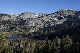
Ralston Peak is a mountain in the Sierra Nevada mountain range to the west of Lake Tahoe within the Desolation Wilderness in El Dorado County, California. Ralston Peak is a very popular mountain to summit for the views of the wilderness area as it lies very near U.S. Route 50. The easiest trailhead to the summit can be found in Camp Sacramento a few miles west of Echo Summit.
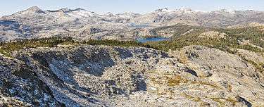
View of Lake Aloha from Ralston Peak
References
- 1 2 "Ralston Peak, California". Peakbagger.com. Retrieved 2009-08-14.
- 1 2 "Tahoe OGUL Peak List". Western State Climbers. Retrieved 2014-01-19.
- ↑ "Ralston Peak". Geographic Names Information System. United States Geological Survey. Retrieved 2009-08-13.
External links
- "Mt. Ralston Peak". Trailspotting. Retrieved 2009-08-14.
This article is issued from Wikipedia - version of the 4/10/2016. The text is available under the Creative Commons Attribution/Share Alike but additional terms may apply for the media files.