Rashidiya (Dubai Metro)
الراشدية | |||||||||||
|---|---|---|---|---|---|---|---|---|---|---|---|
 | |||||||||||
| Line(s) | |||||||||||
| Platforms | 1 island platform, 1 side platform | ||||||||||
| Tracks | 3 | ||||||||||
| Construction | |||||||||||
| Disabled access | Yes | ||||||||||
| Other information | |||||||||||
| Station code | 11 | ||||||||||
| Fare zone | 5 | ||||||||||
| History | |||||||||||
| Opened | 9 September 2009 | ||||||||||
| Traffic | |||||||||||
| Passengers (2011) |
2.634 million | ||||||||||
| Services | |||||||||||
| |||||||||||
Rashidiya (Arabic: الراشدية, Arabic pronunciation: [arːaʃidiːja]) is a rapid transit station on the Red Line of the Dubai Metro in Dubai. The eastern terminus of the line, it is one of three Metro stations with a park and ride lot, the others being Etisalat and Nakheel Harbour and Tower.[1]
Location
Rashidiya station is located in Al Rashidiya, a community of eastern Dubai. A residential area, most points of interest near the station are schools and community centres, although Rashidiya is the closest Metro station to the Dubai Airport Expo.[1] The Royal Wing of the Dubai International Airport is located quite close to the station.
History
As one of the initial stations of the Dubai Metro, Rashidiya opened on 9 September 2009; trains ran to Nakheel Harbour and Tower and served seven intermediate stations.[2] In 2011, Rashidiya handled 2,634,139 passengers, making it one of the busiest stations on the Dubai Metro.[3]
Station layout
| Wiring | |||||||||||||||||||||||||||||||||||||||||||||||||||||||||||||||||||||||||||||||||||||||||
|---|---|---|---|---|---|---|---|---|---|---|---|---|---|---|---|---|---|---|---|---|---|---|---|---|---|---|---|---|---|---|---|---|---|---|---|---|---|---|---|---|---|---|---|---|---|---|---|---|---|---|---|---|---|---|---|---|---|---|---|---|---|---|---|---|---|---|---|---|---|---|---|---|---|---|---|---|---|---|---|---|---|---|---|---|---|---|---|---|---|
Legend
| |||||||||||||||||||||||||||||||||||||||||||||||||||||||||||||||||||||||||||||||||||||||||
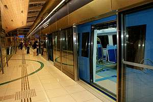
Rashidiya is one of the few stations of the Dubai Metro classed as a type 3 elevated station, indicating it has three tracks rather than the usual two. This allows trains to be held and stored easily. The tracks to and from Rashidiya parallel the southern side of Airport Road, continuing eastward to one of the network's depots.
Platform layout
| Platform | Line | Destination |
|---|---|---|
| Rashidiya platform | ■Red Line(Up) | Arrival Only |
| Jebel Ali platform | ■Red Line(Down) | For Union, Dubai Marina, Jebel Ali |
| Platform 3 | ■Red Line(Down) | For Union, Dubai Marina, Jebel Ali |
References
- 1 2 Train times and landmarks RTA Retrieved 2013-01-03
- ↑ Dubai Metro opens today New Civil Engineer Retrieved 2012-12-30
- ↑ RTA statistics selection RTA Retrieved 2013-01-29
Coordinates: 25°13′48″N 55°23′29″E / 25.23000°N 55.39139°E