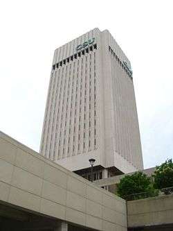
Rhodes Tower
| James A. Rhodes Tower | |
|---|---|
|
CSU's Rhodes Tower from East 22nd | |
| General information | |
| Type | Library and Staff Offices |
| Location |
2121 Euclid Avenue Cleveland, Ohio, USA |
| Construction started | 1968 |
| Completed | 1971 |
| Opening | September 21, 1971 |
| Cost | $ 21.7 million |
| Owner | Cleveland State University |
| Height | |
| Antenna spire | 363 feet |
| Top floor | 20 |
| Design and construction | |
| Architect | Rode, Guenther, and Bonebrake |
The James A. Rhodes Tower (formerly University Tower) is a 21-story, 363-foot skyscraper in Cleveland, Ohio, United States. It is owned by Cleveland State University. It is the second-tallest educational-purposed building in the United States (behind the Cathedral of Learning.) It currently houses the university's main library on the first eight floors and administration offices for many of the university's academic departments on the upper level floors. It previously held classrooms on the first two floors. It is the tallest structure on the Cleveland State campus, followed by Fenn Tower and the tallest academic building in Ohio.[1] The tower was named after former Ohio Governor James A. Rhodes who is responsible for signing the legislation that created The Cleveland State University on December 18, 1964.[2]
Construction
CSU Rhodes Tower was built between 1968-71. The Brutalist structure was designed by the Cleveland architectural firm of Rode, Guenther, and Bonebrake.[3] This style was very prevalent in the 1960's and 1970's in Cleveland and can be seen in the housing projects made in Central and Hough, the Cuyahoga County Justice Center Complex the Cleveland Museum of Art, and AT Tower. It was built at a cost of $21,700,000 including the 2001 renovation. It is a steel structure, clad in white precast concrete panels. There are 2140 separate panels that make up the facing of the massive square tower.[4] When the tower was built, there was controversy over floors shifting; the shifting was caused by bad bolt fasteners imported from Japan. These bolts had to be replaced with bolts made in the US.
Position on campus
On September 21, 1971 University Tower opened for university use. The University Tower was and remains CSU's main focal point and it opens the Downtown Cleveland skyline to the east. In addition, the tower sits as almost the exact geographic center of the campus and is used as a reference point when guiding students and visitors towards points of the campus grounds. The tower building actually sits high above the street level as the Cleveland State University Library is housed in the bottom of the building platforms first 8 floors.
History
In 1981, the tower was renamed after Governor James A. Rhodes.[5] In 2001, a major renovation of the tower was commenced to fix the problems regarding lack of insulation from the weather and leaks caused by this that were never addressed when the tower was built.[6] In 2002, CSU placed signs on the top of the tower [7] In December 2011, CSU officials announced plans to mothball portions of the building due to the prohibitive cost of renovation, including asbestos abatement.[8] However, if this is going to occur has not been decided. The top floors are still being used for college administration offices.
See also
References
- ↑ "Ohio Diagram of tallest buildings page 2of9". Retrieved on 2105-09-30
- ↑ Van Tassel, D.D. & Garbowski, J.J. (1987). The encyclopedia of Cleveland history. Indiana University Press:Bloomington, Indiana.
- ↑ Cleveland: A Brutalist Tour
- ↑ "Rhodes Tower, Cleveland". Retrieved on 2015-09-30
- ↑ Cleveland State University Today (2007). HarrisConnect: Chesapeake, Virginia.
- ↑ "Cleveland State University, Rhodes Tower" (PDF).Retrieved on 2015-09-30
- ↑ Hoefler, S.P. (2003). Images of America:Cleveland's downtown architecture. Arcadia Publishing:Charleston, South Carolina.
- ↑ Cleveland State University to close portions of Rhodes Tower
| Wikimedia Commons has media related to Rhodes Tower. |
- Toman, James. Cleveland's Changing Skyline. 1984 Cleveland Landmark Press
Coordinates: 41°30′11.4″N 81°40′32.2″W / 41.503167°N 81.675611°W
