River Deel
| River Deel | |
|---|---|
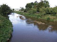
 River Deel west of Rathkeale | |
| Native name | An Daoil |
| Etymology | From Irish daol, "chafer" |
| Country | Ireland |
| Basin | |
| Main source | near Dromina, County Cork |
| River mouth | Atlantic Ocean via Shannon Estuary |
| Basin size | 481 square kilometres (186 sq mi) |
| Physical characteristics | |
| Length | 63.2 kilometres (39.3 mi) |
| Discharge |
|
The River Deel (Irish: An Daoil) is in County Cork and County Limerick, Ireland.[1]
The river rises near Dromina in north County Cork and flows north into County Limerick for over 60 km to enter the Shannon Estuary at Askeaton.
After it rises it passes the flowing areas, first Milford and down towards Belville bridge, then on to Castlemahon (Mahoonagh) and nearby Newcastle West, running parallel to the main Limerick-Killarney N21 road, to reach Rathkeale.
After leaving Rathkeale, the river crosses the N21 and heads for its confluence and estuary at Askeaton.
Name
The Deel derives its name from daol, an Irish word for a beetle, insect or worm, because of its winding, bending shape.
Fishing
The Deel was once a good salmon and grilse fishery but now is mainly fished for brown trout.
References
- ↑ Ordnance Survey of Ireland: Rivers and their Catchment Basins 1958 (Table of Reference)
External links
| Wikimedia Commons has media related to River Deel. |
Coordinates: 52°37′14″N 8°59′19″W / 52.620661°N 8.988528°W