Ohio State Route 126
| ||||
|---|---|---|---|---|
 | ||||
| Route information | ||||
| Maintained by ODOT | ||||
| Length: | 41.23 mi[1][2] (66.35 km) | |||
| Existed: | 1926 – present | |||
| Major junctions | ||||
| West end: |
| |||
|
| ||||
| East end: |
| |||
| Location | ||||
| Counties: | Butler, Hamilton, Clermont | |||
| Highway system | ||||
| ||||

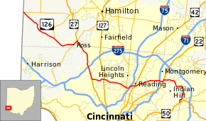
State Route 126 (SR 126) is a state route starting at the Ohio-Indiana border, at a split with State Route 129 near Scipio, Ohio, and ending east of Cincinnati at an intersection with U.S. Route 50 in Milford. State Route 126 is locally known for comprising most of Ronald Reagan Cross County Highway.
History
Prior to the completion of Ronald Reagan Cross County Highway in 1997, the central portion of State Route 126 between Ross and Montgomery consisted of West Kemper Road, Springfield Pike (State Route 4), Glendale Milford Road, Kenwood Road, and Cooper Road.[3] On October 28, 1997, the Ohio Department of Transportation (ODOT) took over Ronald Reagan Highway, except for the segment west of Colerain Avenue.[4] State Route 126 was rerouted over the highway, while Kemper, Glendale Milford, Kenwood, and Cooper roads were returned to local authorities.[5]
Major junctions
| County | Location | mi[2] | km | Exit | Destinations | Notes | ||
|---|---|---|---|---|---|---|---|---|
| Butler | Reily–Morgan township line | 0.00 | 0.00 | Indiana state line | ||||
| 0.02 | 0.032 | Western terminus of SR 129 | ||||||
| Morgan Township | 7.66 | 12.33 | Southern terminus of SR 748 | |||||
| Ross Township | 11.46 | 18.44 | Western end of SR 128 concurrency | |||||
| 12.54 | 20.18 | Interchange; eastern end of SR 128 concurrency; western end of US 27 concurrency | ||||||
| West end of expressway | ||||||||
| Hamilton | Colerain Township | 13.27 | 21.36 | — | East Miami River Road – Fairfield | Grade-separated single-loop intersection | ||
| 14.82 | 23.85 | — | Kemper Road | Interchange | ||||
| East end of expressway | ||||||||
| 17.56 | 28.26 | Exit 33 (I-275) | ||||||
| 19.75– 19.92 | 31.78– 32.06 | — | Interchange; eastern end of US 27 concurrency | |||||
| West end of freeway | ||||||||
| Mount Healthy–North College Hill city line | 22.13 | 35.61 | — | |||||
| Springfield Township | 23.90 | 38.46 | — | Winton Road | Westbound exit / eastbound entrance only | |||
| 24.58 | 39.56 | — | Galbraith Road / Winton Road | |||||
| Cincinnati | 26.68– 27.06 | 42.94– 43.55 | — | Exit 10A (I-75); no access from I-75 southbound, from westbound SR 126 to I-75 northbound | ||||
| Reading | 28.10 | 45.22 | — | Eastbound exit / westbound entrance only | ||||
| 28.52 | 45.90 | — | Galbraith Road to | Westbound exit / eastbound entrance only | ||||
| Amberley | 29.39 | 47.30 | — | Ridge Road | ||||
| Blue Ash | 31.27 | 50.32 | — | Plainfield Road / Hunt Road | ||||
| 31.91– 32.15 | 51.35– 51.74 | — | Blue Ash Road / Kenwood Road | |||||
| Montgomery–Sycamore Township line | East end of freeway | |||||||
| 32.73 | 52.67 | Exit 14 (I-71) | ||||||
| Montgomery | 33.34 | 53.66 | — | Interchange; western end of US 22 / SR 3 concurrency | ||||
| 33.99 | 54.70 | Western end of US 22 / SR 3 concurrency | ||||||
| Clermont |
No major junctions | |||||||
| Hamilton | Milford | 41.23 | 66.35 | Western terminus of SR 28 | ||||
1.000 mi = 1.609 km; 1.000 km = 0.621 mi
| ||||||||
See also
References
- ↑ ODOT. "Technical Services Straight Line Diagrams". Retrieved April 30, 2010.
- 1 2 "Division of Planning - Office of Technical Services - Destape files". ODOT. July 16, 2013. Retrieved November 29, 2013 — Butler County, Hamilton County, Clermont County
- ↑ Engels Maps (1997). Hamilton County Street Map (Map). 1½ in : 1 mi. Huff Reality. §§ L-51, R-55.
- ↑ Griggs, France (October 27, 1997). "Cross County speeds miles, spans years". News. The Cincinnati Post. E. W. Scripps Company. Retrieved October 10, 2015 – via HighBeam Research. (subscription required (help)).
- ↑ Michaud, Anne (April 15, 1997). "Ohio wants to dump 'Reagan' for SR 126". The Cincinnati Enquirer. Gannett Company. Retrieved October 10, 2015.
External links
- Ronald Reagan Cross County Highway at Cincinnati-Transit.net
- Indiana Highway Ends: Indiana SR 252 (with western terminus of Ohio SR 126)
- Highways of the State of Ohio: Ohio State Route 126, Hamilton County, Bill Burmaster