Saint-Souplet
| Saint-Souplet | |
|---|---|
 | |
 Saint-Souplet | |
|
Location within Hauts-de-France region  Saint-Souplet | |
| Coordinates: 50°03′19″N 3°31′53″E / 50.0553°N 3.5314°ECoordinates: 50°03′19″N 3°31′53″E / 50.0553°N 3.5314°E | |
| Country | France |
| Region | Hauts-de-France |
| Department | Nord |
| Arrondissement | Cambrai |
| Canton | Le Cateau-Cambrésis |
| Intercommunality | Caudrésis–Catésis |
| Government | |
| • Mayor (2008–2014) | Henri Quoniou |
| Area1 | 12.66 km2 (4.89 sq mi) |
| Population (2009)2 | 1,288 |
| • Density | 100/km2 (260/sq mi) |
| Time zone | CET (UTC+1) |
| • Summer (DST) | CEST (UTC+2) |
| INSEE/Postal code | 59545 / 59360 |
| Elevation | 101–161 m (331–528 ft) |
|
1 French Land Register data, which excludes lakes, ponds, glaciers > 1 km² (0.386 sq mi or 247 acres) and river estuaries. 2 Population without double counting: residents of multiple communes (e.g., students and military personnel) only counted once. | |
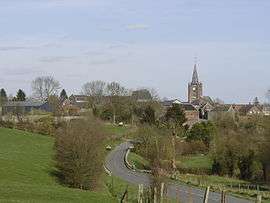
Saint-Souplet is a commune in the Nord department in northern France.
Geography
Saint Souplet-Escaufourt is on the (departmental) route 115. It is part of the canton Cateau-Cambrésis, 6 km from Cateau, 30 km south east of Cambrai and 86 km from Lille.
Located in the south of Cateau-Cambrésis and on the doorstep of Avesnois, Saint-Souplet is surrounded by the nature landscapes of Hainaut : grasslands bordered by 'bocage' hedges and vast expanses of cultivated fields. It extends along the Selle, a tributary river of the Scheldt, which arises in Aisne and winds some 50 kilomètres through Département du Nord.
History
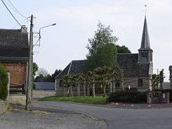
Saint-Souplet owes its name to its patron saint, saint Sulpice le Pieux archbishop of Bourges in the 8th century.
In 1973, it absorbed Escaufourt, located previously in Aisne
Heraldry
_Nord-France.svg.png) |
The arms of Saint-Souplet are blazoned : D'or à trois croissants de gueules. These arms are those of D'Anneux, marquis of Wargnies and lords of Saint-Souplet.[1] |
Demography
| Year | 1962 | 1968 | 1975 | 1982 | 1990 | 1999 | 2006 |
|---|---|---|---|---|---|---|---|
| Population | 1 646 | 1 684 | 1 622 | 1 482 | 1 333 | 1 311 | 1 289 |
| From the year 1962 on: No double counting—residents of multiple communes (e.g. students and military personnel) are counted only once. | |||||||
Escaufourt
The name Escaufourt comes from fours à chaux (chalk oven). in the 12th century, Escaufourt was in the parish of Honnechy. Before the merger with Saint-Souplet un 1973, Escaufourt was an enclave of Aisne within Nord.
Heraldry
.svg.png) |
The arms of Escaufourt are blazoned :[2] Gules, 3 chevrons, in chief a label of 4 points Or. |
See also
References
- ↑ Source: Cambrésis terre d'histoire
- ↑ Dictionnaire historique du département de l'Aisne Par Maximilien Melleville - Publié par M. Melleville, 1865 - p. 362
| Wikimedia Commons has media related to Saint-Souplet. |