Sakaide, Kagawa
| Sakaide 坂出市 | ||
|---|---|---|
| City | ||
| ||
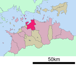 Location of Sakaide in Kagawa Prefecture | ||
 Sakaide Location in Japan | ||
| Coordinates: 34°19′N 133°52′E / 34.317°N 133.867°ECoordinates: 34°19′N 133°52′E / 34.317°N 133.867°E | ||
| Country | Japan | |
| Region | Shikoku | |
| Prefecture | Kagawa Prefecture | |
| Government | ||
| • Mayor | Toshiaki Matsuura | |
| Area | ||
| • Total | 92.46 km2 (35.70 sq mi) | |
| Population (April 2008) | ||
| • Total | 56,365 | |
| • Density | 610/km2 (1,600/sq mi) | |
| Symbols | ||
| • Tree | Sangoju (Viburnum odoratissimum var. awabuki) | |
| • Flower | Sakura and Cosmos | |
| Time zone | Japan Standard Time (UTC+9) | |
| City hall address |
2-3-5, Muromachi, Sakaide-shi, Kagawa-ken 762-8601 | |
| Website |
www | |

Sakaide (坂出市 Sakaide-shi) is a city located in Kagawa Prefecture, Japan.
As of 2008, the city has an estimated population of 56,365 and a population density of 610 persons per km². The total area is 92.46 km².
The city was founded on July 1, 1942. The Great Seto Bridge connects it with Kurashiki, Okayama Prefecture across the Inland Sea.
Sakaide is also sister cities with Sausalito, California
External links
| Wikimedia Commons has media related to Sakaide, Kagawa. |
- Sakaide City official website (Japanese)
This article is issued from Wikipedia - version of the 11/5/2015. The text is available under the Creative Commons Attribution/Share Alike but additional terms may apply for the media files.