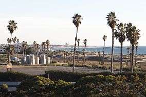
San Buenaventura State Beach
| San Buenaventura State Beach | |
|---|---|
| Ventura State Beach | |
 | |
  | |
| Location | Ventura County, California, USA |
| Nearest city | Ventura, California |
| Coordinates | 34°16′3″N 119°16′43″W / 34.26750°N 119.27861°W / 34.26750; -119.27861Coordinates: 34°16′3″N 119°16′43″W / 34.26750°N 119.27861°W / 34.26750; -119.27861 |
| Governing body | California Department of Parks and Recreation |
| Website | http://www.parks.ca.gov/?page_id=60 |
San Buenaventura State Beach is a beach located in Ventura, California. The primary entrance is located at 901 Pedro Street, off of the 101 Freeway.
This beach consists of a 1,700-foot (520 m) pier that has a snack bar, restaurant, and bait shop. People often come to this beach to surf, swim, and picnic. This is the beginning of the Omer Rains Bike Trail[1] system that leads to other nearby beaches.
Several special events take place in this place, such as the Pirate Festival, triathlon, the "Seaside Invitational" cross country meet[2] and volleyball tournaments.[3]
The nesting of the Snowy plover is monitored here, and temporary informational/warning signs and fences (or ropes) are erected near nest sites during the breeding season. To help in the recovery of the bird, nonnative vegetation that threatens the beach habitat has been removed, and beach goers are educated as to the sensitive nature of the area to dunes and other sandy areas.[4]
References
- ↑ https://www.traillink.com/trail/omer-rains-coastal-bike-trail.aspx
- ↑ http://seaside-xc-invite.runnerspace.com
- ↑ San Buenaventura SB, accessed November 25, 2009
- ↑ "Snowy Plover Protection" California Department of Parks and Recreation Accessed 5 November 2014
External links
| Wikimedia Commons has media related to San Buenaventura State Beach. |
| Schools | |
|---|---|
| Colleges and universities | |
| Libraries | |
| Landmarks |
|
| Transportation | |
| Healthcare | |
This list is incomplete. | |