Sanam Khli
| Sanam Khli สนามคลี (English: Open Field) | |
|---|---|
| Tambon | |
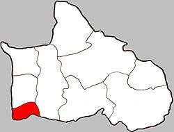 Location of Sanam Khli within the amphoe | |
| Coordinates: 16°32′30″N 100°15′00″E / 16.54167°N 100.25000°ECoordinates: 16°32′30″N 100°15′00″E / 16.54167°N 100.25000°E | |
| Country | Thailand |
| Province | Phitsanulok |
| Amphoe | Bang Krathum |
| Population (2005) | |
| • Total | 2,535 |
| Time zone | Thailand (UTC+7) |
| Postal code | 65110 |
| Geocode | 650504 |
| Chief watercourse | Nan River |
Sanam Khli (Thai: สนามคลี) is a subdistrict (tambon) in the Bang Krathum district of Phitsanulok Province (amphoe), Thailand.
Geography
Sanam Khli borders Khok Salut to the north, Bang Krathum to the east, and Phichit Province to the south and west. Most of Sanam Khli lies within the Nan Basin, although a narrow strip of land on the west side of the subdistrict lies within the Yom Basin. Both basins are part of the Chao Phraya Watershed. The Nan River flows through Sanam Khli at Ban Sanam Khli.
Administration
The subdistrict is subdivided into 6 smaller divisions called (muban). There are 2 villages in Sanam Khli. Ban Sanam Khli occupies 5 of the muban. Sanam Khli is administrated by a Tambon administrative organization (TAO). The muban in Sanam Khli are enumerated as follows: [1]
| No. | English | Thai |
| 1-5 | Ban Sanam Khli | บ้านสนามคลี |
| 6 | Ban Bueng Bua | บ้านบึงบัว |
Temples
Sanam Khli is home to the following two temples, which are both in Ban Sanam Khli:[2]
- Wat Sanam Khli (East Temple)
- Wat Sanam Khli (West Temple)