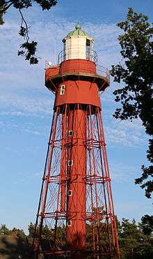
Sandhammaren
 Sandhammaren Lighthouse | |
| Location | East of Ystad, Sweden |
|---|---|
| Coordinates | 55°23′12″N 14°11′35″E / 55.386746°N 14.193058°ECoordinates: 55°23′12″N 14°11′35″E / 55.386746°N 14.193058°E |
| Year first constructed | 1862 |
| Automated | 1976 |
| Construction | cast iron skeletal tower |
| Tower shape | conical skeletal tower with central cylinder, balcony and lantern |
| Markings / pattern | red tower, greenish lantern dome |
| Height | 29.5 metres (97 ft) |
| Focal height | 32 metres (105 ft) |
| Current lens | 2° Focal plane lens |
| Range | 22 nautical miles (41 km; 25 mi) |
| Characteristic | Fl W 5s. |
| Admiralty number | C2460 |
| NGA number | 5648 |
| ARLHS number | SWE-055 |
| Sweden number | SV-6545 |
| Managing agent | Swedish Maritime Administration (Sjöfartsverket)[1] |
Sandhammaren is a Swedish lighthouse, and the name of both a beach and a point east of Ystad in Scania. At first two identical lighthouses were constructed, because it was a risk to mistake this lighthouse with the one on Ertholmene. The flame first ran on colza oil. Later on (1891), one of the lighthouses was put out of service and moved to Pite-Rönnskär in Norrland, at the same time the lamp was transformed to a paraffin lamp. The lighthouse was electrified in 1952.
The Swedish Maritime Administration owns and runs the lighthouse.
See also
References
- ↑ Sandhammaren The Lighthouse Directory. University of North Carolina at Chapel Hill. Retrieved April 6, 2016
- Rowlett, Russ. "Lighthouses of Sweden: Halland". The Lighthouse Directory. University of North Carolina at Chapel Hill. Retrieved 9 September 2008.
External links
- Sjofartsverket (English)
- The Swedish Lighthouse Society
| Wikimedia Commons has media related to Sandhammarens fyr. |
This article is issued from Wikipedia - version of the 4/6/2016. The text is available under the Creative Commons Attribution/Share Alike but additional terms may apply for the media files.