Santa Luċija
For the settlement on Gozo, see Santa Luċija, Gozo.
| Santa Luċija | |||
|---|---|---|---|
| Local council | |||
|
Santa Luċija Parish Church | |||
| |||
 | |||
| Coordinates: 35°51′45″N 14°30′16″E / 35.86250°N 14.50444°ECoordinates: 35°51′45″N 14°30′16″E / 35.86250°N 14.50444°E | |||
| Country |
 Malta Malta | ||
| Region | Southern Region | ||
| District | Southern Harbour District | ||
| Borders | Gudja, Għaxaq, Luqa, Paola, Tarxien, Żejtun | ||
| Government | |||
| • Mayor | Terrence Ellul (PL) | ||
| Area | |||
| • Total | 0.7 km2 (0.3 sq mi) | ||
| Population (March 2014) | |||
| • Total | 2,997 | ||
| • Density | 4,300/km2 (11,000/sq mi) | ||
| Demonym(s) | Ta' Santa Luċija | ||
| Time zone | CET (UTC+1) | ||
| • Summer (DST) | CEST (UTC+2) | ||
| Postal code | SLC | ||
| Dialing code | 356 | ||
| ISO 3166 code | MT-53 | ||
| Patron saint | Pope Pius X | ||
| Website | Official website | ||
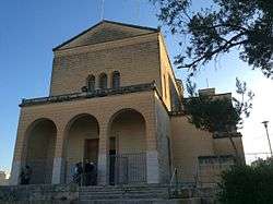


Santa Luċija is a village in the Southern Region of Malta, with a population of 2997 as of March 2014.[1] It is one of the modern towns developed in Malta during the 20th century. By virtue of an article which appeared in Government Gazette of 7 July 1961 the area between Tal-Barrani (Tarxien By-Pass) and Luqa By-Pass. Santa Luċija was named after a 16th-century chapel located in the vicinity. The Parish Church is dedicated to Pius X. It is home of the Chinese Garden of Serenity (a Chinese-built public garden). Located there is a hypogeum which was discovered in 1973.
Attractions and places of interest
- Chinese Garden of Serenity, a Chinese traditional garden
- Sphere of Life, a commemorative monument by Paul Vella Critien[2]
- Votive Column, a monument representing fertility[3]
Zones in Santa Luċija
- Bir-Ġurat
- Roqba
- Sqajjaq t'Isfel
- Ta' Garnaw
- Ta' Garriba
- Taċ-Ċagħki
- Tal-Lampat
- Tax-Xewk
Santa Luċija Main Roads
- Dawret it-Torri (Tower By-Pass)
- Triq Katarina Vitale (Catherine Vitale Street)
- Triq Marija DeDominicis (Maria De Dominicas Street)
- Triq Ħal-Luqa (Luqa Road)
- Triq il-Begonja (Begonia Street)
- Triq il-Pepprin (Poppies Street)
- Triq il-Prinjoli (Aleppo Pine Street)
- Triq Tal-Barrani (Tal-Barrani Road)
- Vjal l-Oleandri (Oleandri Avenue)
References
- ↑ "Estimated Population by Locality 31st March, 2014". Government of Malta. 16 May 2014. Archived from the original on 21 June 2015.
- ↑ http://www.timesofmalta.com/articles/view/20110710/arts-entertainment/Sphere-of-Life-at-Sta-Lu-ija.375050
- ↑ http://www.timesofmalta.com/articles/view/20050613/local/sculpture-garden-planned-in-sta-lucija.87304
External links
| Malta Local Councils |
| |
|---|---|---|
| Malta Administrative Committees |
| |
| Gozo Local Councils | ||
| Gozo Administrative Committees | ||
This article is issued from Wikipedia - version of the 9/20/2016. The text is available under the Creative Commons Attribution/Share Alike but additional terms may apply for the media files.